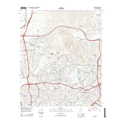
2015 Map of La Mesa
USGS Topo · Published 2015About this map
The San Diego River carves a central path through this terrain, connecting the steep elevations of Mission Gorge to the expanding urban corridors of eastern San Diego. The landscape is defined by its dramatic topographic shifts, where residential communities like Allied Gardens and Del Cerro occupy the ridges overlooking Mission Valley. High points such as Fortuna Mtn and Cowles Mtn provide natural landmarks amidst a dense network of suburban growth. The presence of major educational institutions, including San Diego State University and Grossmont College, reflects the area's mid-century development as a regional hub for education and civic life. Infrastructure is heavily represented by the Second San Diego Aqueduct and the Murray Reservoir, highlighting the critical water management systems required to support the populations of La Mesa and El Cajon.
Find a feature on this map
62 named features on this map. Tap any name to fly to it.
Don’t see what you’re looking for? This feature index may not catch every label — zoom into the map to look around manually.
Map Details
Editions of this 2015 La Mesa Map
This is the sole edition of this map. No revisions or reprints were ever made.
Other maps of this area

1893 · El Cajon
USGS Topo · 1:62,500

1901 · Elcajon
USGS Topo · 1:62,500

1903 · Cuyamaca
USGS Topo · 1:125,000

1903 · La Jolla
USGS Topo · 1:62,500

1903 · Elcajon
USGS Topo · 1:62,500

1904 · San Diego
USGS Topo · 1:62,500

1904 · Southern California Sheet No. 2
USGS Topo · 1:250,000

1930 · La Jolla
USGS Topo · 1:62,500

1930 · San Diego
USGS Topo · 1:62,500

1939 · El Cajon
USGS Topo · 1:62,500