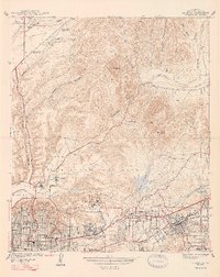
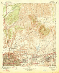
1947 Map of La Mesa
USGS Topo · Published 1947About this map
State College stands at the center of this 1940s landscape, marking the eastward expansion of San Diego's academic and residential footprint. The surrounding neighborhoods of Normal Hts, Kensington Park, and East San Diego show a dense street grid of schools and residences, including Hoover High Sch and the Sacred Heart Sch, while the Rest Haven Preventorium occupies a quiet pocket of the hills. North of the developed blocks, the San Diego River winds through Mission Valley and the steep walls of Mission Gorge. This rugged terrain remains largely dominated by military activity and water infrastructure, featuring the Marine Corps Gun Range and the Murray Reservoir. The map illustrates the sharp boundary between the burgeoning mid-century suburban grid and the undeveloped canyons of Fortuna Mtn and Cowles Mtn.
Find a feature on this map
46 named features on this map. Tap any name to fly to it.
Don’t see what you’re looking for? This feature index may not catch every label — zoom into the map to look around manually.
Map Details
Editions of this 1947 La Mesa Map
2 editions found
Other maps of this area

1893 · El Cajon
USGS Topo · 1:62,500

1901 · Elcajon
USGS Topo · 1:62,500

1903 · Cuyamaca
USGS Topo · 1:125,000

1903 · La Jolla
USGS Topo · 1:62,500

1903 · Elcajon
USGS Topo · 1:62,500

1904 · San Diego
USGS Topo · 1:62,500

1904 · Southern California Sheet No. 2
USGS Topo · 1:250,000

1930 · La Jolla
USGS Topo · 1:62,500

1930 · San Diego
USGS Topo · 1:62,500

1939 · El Cajon
USGS Topo · 1:62,500