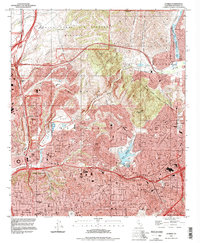
1994 Map of La Mesa
USGS Topo · Published 1998About this map
Marine Corps Air Station Miramar dominates the northern landscape of this mid-1990s record, overlooking the rugged canyons of Kearny Mesa and Murphy Canyon. The area exhibits the dense suburban expansion of eastern San Diego, La Mesa, and El Cajon, centered around the institutional anchor of San Diego State University and the historic Mission San Diego de Alcala.
Find a feature on this map
67 named features on this map. Tap any name to fly to it.
Don’t see what you’re looking for? This feature index may not catch every label — zoom into the map to look around manually.
Map Details
Editions of this 1994 La Mesa Map
This is the sole edition of this map. No revisions or reprints were ever made.
Other maps of this area

1893 · El Cajon
USGS Topo · 1:62,500

1901 · Elcajon
USGS Topo · 1:62,500

1903 · Cuyamaca
USGS Topo · 1:125,000

1903 · La Jolla
USGS Topo · 1:62,500

1903 · Elcajon
USGS Topo · 1:62,500

1904 · San Diego
USGS Topo · 1:62,500

1904 · Southern California Sheet No. 2
USGS Topo · 1:250,000

1930 · La Jolla
USGS Topo · 1:62,500

1930 · San Diego
USGS Topo · 1:62,500

1939 · El Cajon
USGS Topo · 1:62,500