
1981 Map of La Plant SW
USGS Topo · Published 1981About this map
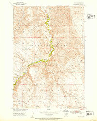
No Heart and several family-run ranching operations define this Dewey County landscape, which sits entirely within the Cheyenne River Indian Reservation. Mapped from 1974 aerial photography, the terrain is shaped by an intricate network of drainages, most notably the meandering Virgin Creek which snakes north through the center of the sheet. The settlement pattern is sparse, tied closely to water sources like Lee Dam and the various branches of the creek system. To the south, the headwaters of No Heart Creek and the confluence of the East Branch and West Branch Willow Creek illustrate the hydrologic structure of the plains. Named landmarks like Agnew Ranch and H Triangle Ranch provide specific points of interest for those tracing local land use and genealogical ties in this portion of South Dakota during the early 1980s.
Find a feature on this map
12 named features on this map. Tap any name to fly to it.
Don’t see what you’re looking for? This feature index may not catch every label — zoom into the map to look around manually.
Map Details
Editions of this 1981 La Plant SW Map
This is the sole edition of this map. No revisions or reprints were ever made.
Other maps of this area
1951 · Virginia
USGS Topo · 1:24,000
1951 · Ridgeview NE
USGS Topo · 1:24,000
1951 · La Plant
USGS Topo · 1:24,000

1953 · McIntosh
USGS Topo · 1:250,000

1954 · Pierre
USGS Topo · 1:250,000

1958 · Pierre
USGS Topo · 1:250,000

1958 · McIntosh
USGS Topo · 1:250,000

1981 · Charlie Creek
USGS Topo · 1:24,000

1981 · No Heart Creek NE
USGS Topo · 1:24,000

1981 · Stove Creek
USGS Topo · 1:24,000