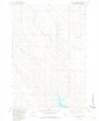
1981 Map of No Heart Creek NE
USGS Topo · Published 1981About this map
The Lake Oahe Elevation 1617 shoreline and its numerous inlets define the southern edge of this ranching landscape within the Cheyenne River Indian Reservation. Surveyed in the mid-1970s and edited in the early 1980s, the map documents a network of family-operated rangelands including the Wayne Ducheneaux Ranch and the Gordon LeCompte Ranch. The terrain is deeply carved by drainage systems, most notably Willow Creek and its various tributaries such as West Branch Willow Creek and Little Willow Creek. This hydrography illustrates the transition from high prairie draws down to the standing water of Willow Creek Bay. The arrangement of ranch houses like the Quentin LeCompte Ranch and Henry Ducheneaux Ranch offers a clear view of the rural settlement patterns and land use in Dewey County during this era.
Find a feature on this map
11 named features on this map. Tap any name to fly to it.
Don’t see what you’re looking for? This feature index may not catch every label — zoom into the map to look around manually.
Map Details
Editions of this 1981 No Heart Creek NE Map
This is the sole edition of this map. No revisions or reprints were ever made.
Other maps of this area

1953 · McIntosh
USGS Topo · 1:250,000

1954 · Pierre
USGS Topo · 1:250,000

1958 · Pierre
USGS Topo · 1:250,000

1958 · McIntosh
USGS Topo · 1:250,000

1965 · Artichoke Butte SW
USGS Topo · 1:24,000

1969 · No Heart Creek SE
USGS Topo · 1:24,000

1969 · Artichoke Butte NW
USGS Topo · 1:24,000

1969 · Patch Skin Buttes SW
USGS Topo · 1:24,000

1969 · No Heart Creek SW
USGS Topo · 1:24,000
1981 · Stove Creek
USGS Topo · 1:24,000