
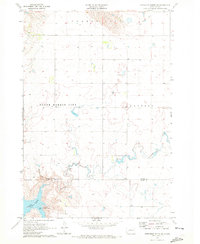
1969 Map of Artichoke Butte NW
USGS Topo · Published 1972About this map
The Lake Oahe Missouri River dominates this stretch of the northern Great Plains, representing a landscape transformed by the mid-century development of the Missouri River Basin. The reservoir's vast waters have inundated the former river valley, though the map still identifies the historical locations of Forest City and South Forest City along its eastern banks. This 1969 survey captures the intersection of Dewey, Potter, and Sully counties, where the western shore is defined by the Cheyenne River Indian Reservation Boundary. Several local drainages, including Pascal Creek, Parker Creek, and Alberts Creek, feed into the reservoir, carving deep draws into the high prairie terrain. The presence of a small Gravel Pit near the river's edge suggests the localized extraction of materials used for road building and infrastructure during this period of regional water management.
Find a feature on this map
12 named features on this map. Tap any name to fly to it.
Don’t see what you’re looking for? This feature index may not catch every label — zoom into the map to look around manually.
Map Details
Editions of this 1969 Artichoke Butte NW Map
This is the sole edition of this map. No revisions or reprints were ever made.
Other maps of this area

1953 · McIntosh
USGS Topo · 1:250,000

1954 · Pierre
USGS Topo · 1:250,000

1958 · Pierre
USGS Topo · 1:250,000

1958 · McIntosh
USGS Topo · 1:250,000

1965 · Artichoke Butte
USGS Topo · 1:24,000

1965 · Artichoke Butte SW
USGS Topo · 1:24,000

1969 · No Heart Creek SE
USGS Topo · 1:24,000

1969 · Patch Skin Buttes SW
USGS Topo · 1:24,000

1969 · Patch Skin Buttes SE
USGS Topo · 1:24,000
1970 · Artichoke Butte NE
USGS Topo · 1:24,000