
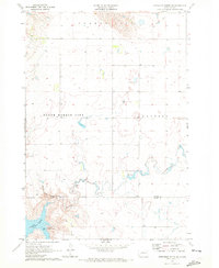
1969 Map of Patch Skin Buttes SW
USGS Topo · Published 1972About this map
The Cheyenne River Indian Reservation Boundary cuts across this Missouri River landscape, following the waters of Lake Oahe and Stove Creek Bay. In this late 1960s survey, the area reflects the massive geographical changes brought by the development of the Missouri River Basin, which transformed the original river channel into a wide reservoir at an elevation of 1608 feet. Rural life is anchored by the Swift Bird Day Sch and the small settlement of Marksville, while Gray Butte stands as a prominent physical landmark above the breaks.
Find a feature on this map
11 named features on this map. Tap any name to fly to it.
Don’t see what you’re looking for? This feature index may not catch every label — zoom into the map to look around manually.
Map Details
Editions of this 1969 Patch Skin Buttes SW Map
This is the sole edition of this map. No revisions or reprints were ever made.
Other maps of this area

1951 · Virginia
USGS Topo · 1:24,000

1953 · McIntosh
USGS Topo · 1:250,000

1954 · Pierre
USGS Topo · 1:250,000

1958 · Pierre
USGS Topo · 1:250,000

1958 · McIntosh
USGS Topo · 1:250,000

1969 · Artichoke Butte NW
USGS Topo · 1:24,000

1969 · Four Bear Creek
USGS Topo · 1:24,000

1969 · Patch Skin Buttes SE
USGS Topo · 1:24,000

1970 · Patch Skin Buttes
USGS Topo · 1:24,000
1970 · Artichoke Butte NE
USGS Topo · 1:24,000