
1981 Map of Stove Creek
USGS Topo · Published 1981About this map
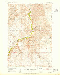
The Gray family ranches define the early 1980s landscape within the Cheyenne River Indian Reservation, illustrating a pattern of widely dispersed rural homesteading in Dewey County. Remote operations like the Oscar Gray Ranch in the north and the Dan Gray Ranch to the south are connected by a network of unimproved roads and cattle trails that follow the natural drainage basins. The area is dominated by the winding course of Stove Creek, which draws several tributaries including Parker Creek across the central plains. To the south, the terrain rises toward the prominent elevation of Scatter Butte, which overlooks the headwaters of Scatter Butte Creek and the East Branch Willow Creek. This survey provides a clear view of how water sources and land ownership shaped settlement in this portion of South Dakota's grasslands during the late twentieth century.
Find a feature on this map
9 named features on this map. Tap any name to fly to it.
Don’t see what you’re looking for? This feature index may not catch every label — zoom into the map to look around manually.
Map Details
Editions of this 1981 Stove Creek Map
This is the sole edition of this map. No revisions or reprints were ever made.
Other maps of this area
1951 · Virginia
USGS Topo · 1:24,000
1951 · La Plant
USGS Topo · 1:24,000

1953 · McIntosh
USGS Topo · 1:250,000

1954 · Pierre
USGS Topo · 1:250,000

1958 · Pierre
USGS Topo · 1:250,000

1958 · McIntosh
USGS Topo · 1:250,000

1969 · Artichoke Butte NW
USGS Topo · 1:24,000

1969 · Patch Skin Buttes SW
USGS Topo · 1:24,000

1970 · Patch Skin Buttes
USGS Topo · 1:24,000

1981 · No Heart Creek NE
USGS Topo · 1:24,000