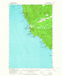
1956 Map of La Push
USGS Topo · Published 1964About this map
The Quileute Indian Res dominates the coastline where the Quillayute River meets the Pacific Ocean, anchoring the settlement of La Push. This mid-century landscape reveals the confluence of the Soleduck River and the Bogachiel River, a vital water network for the region's timber industry. Evidence of that industry is clear in the Logging RR carving through the forests near Little Prairie. To the north, the Mora settlement sits near the Quillayute Outlying Field Naval Res, indicating the area's strategic coastal importance during the era. The shoreline is marked by distinctive rock formations and navigational landmarks, including James Island, the Coast Guard Sta, and the Chilean Memorial Mon at Cape Johnson. This survey provides a look at the Olympic Peninsula's remote western edge, where coastal hamlets like Mora were connected by the Mora Ocean Beach Road before modern highway expansion.
Find a feature on this map
55 named features on this map. Tap any name to fly to it.
Don’t see what you’re looking for? This feature index may not catch every label — zoom into the map to look around manually.
Map Details
Editions of this 1956 La Push Map
Other maps of this area

1935 · Ozette Lake
USGS Topo · 1:62,500

1935 · Lake Pleasant
USGS Topo · 1:62,500

1939 · Forks
USGS Topo · 1:62,500

1942 · Ozette Lake
USGS Topo · 1:62,500

1942 · Lake Pleasant
USGS Topo · 1:62,500

1943 · Copalis Beach
USGS Topo · 1:250,000

1951 · Copalis Beach
USGS Topo · 1:250,000

1953 · Cape Flattery
USGS Topo · 1:250,000

1956 · Destruction Island
USGS Topo · 1:62,500

1956 · La Push
USGS Topo · 1:62,500