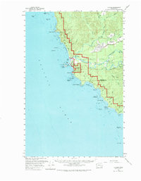
1956 Map of La Push
USGS Topo · Published 1974About this map
Quileute Indian Res serves as the focal point for this mid-century survey of the Pacific coast, centered on the village of La Push. The landscape is dominated by the confluence of the Quillayute River, Solebuck River, and Bogachiel River, which meet just inland from the rocky shoreline. The presence of the Quillayute Outlying Naval Field and a nearby Gravel Pit indicates a post-war shift toward infrastructure and military utility in this previously secluded region. Along the rugged coast, markers like the Chilean Memorial Mon and Giants Graveyard highlight a coastline defined by dangerous waters and maritime history. Inland, the transition from agricultural areas like Little Prairie to industrial features like the Logging RR Road illustrates the era's reliance on both the soil and the timber stands of Olympic National Park.
Find a feature on this map
60 named features on this map. Tap any name to fly to it.
Don’t see what you’re looking for? This feature index may not catch every label — zoom into the map to look around manually.
Map Details
Editions of this 1956 La Push Map
Other maps of this area

1935 · Ozette Lake
USGS Topo · 1:62,500

1935 · Lake Pleasant
USGS Topo · 1:62,500

1939 · Forks
USGS Topo · 1:62,500

1942 · Ozette Lake
USGS Topo · 1:62,500

1942 · Lake Pleasant
USGS Topo · 1:62,500

1943 · Copalis Beach
USGS Topo · 1:250,000

1951 · Copalis Beach
USGS Topo · 1:250,000

1953 · Cape Flattery
USGS Topo · 1:250,000

1956 · Destruction Island
USGS Topo · 1:62,500

1956 · La Push
USGS Topo · 1:62,500