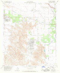
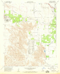
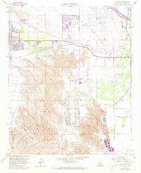
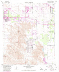
1959 Map of La Quinta
USGS Topo · Published 1968About this map
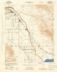
Palm Desert and La Quinta anchor this mid-century look at the lower desert as irrigation and recreation rapidly transformed the Coachella Valley. The landscape is defined by the contrast between organized agricultural grids and the emergence of desert leisure, evidenced by the Bermuda Dunes Country Club and the Indian Wells Golf Course. To the south, the terrain rises sharply into Indio Mountain and the State Game Refuge, where canyons like Deep Canyon and Bear Creek drain toward the valley floor.
Find a feature on this map
54 named features on this map. Tap any name to fly to it.
Don’t see what you’re looking for? This feature index may not catch every label — zoom into the map to look around manually.
Map Details
Editions of this 1959 La Quinta Map
4 editions found
Other maps of this area

1904 · Indio
USGS Topo · 1:125,000

1941 · Toro Peak
USGS Topo · 1:62,500

1941 · Coachella
USGS Topo · 1:62,500

1941 · Edom
USGS Topo · 1:62,500
1943 · Coachella
USGS Topo · 1:62,500

1944 · Toro peak
USGS Topo · 1:62,500

1944 · Edom
USGS Topo · 1:62,500

1944 · Pinyon Well
USGS Topo · 1:62,500

1947 · Santa Ana
USGS Topo · 1:250,000

1949 · Santa Ana
USGS Topo · 1:250,000