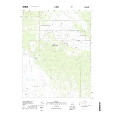
2020 Map of La Sal East
USGS Topo · Published 2020About this map
Old La Sal occupies a central position on this eastern Utah landscape, where the high desert meets the wooded slopes of the Manti-La Sal National Forest. The map reveals a complex network of forest and county roads, such as Co Rd 124 and Ranger Station Rd, that navigate the transition between deep incisions like Doe Canyon and the prominent Pine Ridge. This 2020 survey illustrates the vital role of water management in a dry environment, evidenced by Wilcox Reservoir and various isolated sources including Coyote Spring and Deer Spring. The terrain is marked by numerous drainage systems like La Sal Cr and Beaver Cr, while the presence of Snow Ball Mine Rd hints at the area's history of extraction and mountain access. Researchers will find a high degree of detail regarding land division and official structures, including the La Sal Guard station.
Find a feature on this map
33 named features on this map. Tap any name to fly to it.
Don’t see what you’re looking for? This feature index may not catch every label — zoom into the map to look around manually.
Map Details
Editions of this 2020 La Sal East Map
This is the sole edition of this map. No revisions or reprints were ever made.
Other maps of this area

1885 · La Sal
USGS Topo · 1:250,000

1954 · Mt Peale 1 SE
USGS Topo · 1:24,000

1954 · Mt Peale 1 NE
USGS Topo · 1:24,000

1954 · Mt Peale 4 NE
USGS Topo · 1:24,000

1954 · Mt Peale 4 NW
USGS Topo · 1:24,000

1954 · Mt Peale 3 NE
USGS Topo · 1:24,000

1954 · Mt Peale 1 SW
USGS Topo · 1:24,000

1954 · Mt Peale 1 NW
USGS Topo · 1:24,000

1954 · Mt Peale 2 SE
USGS Topo · 1:24,000

1954 · Mt Peale 2 NE
USGS Topo · 1:24,000