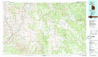
1982 Map of La Sal
USGS Topo · Published 1983About this map
Canyonlands National Park dominates the western landscape of this 1982 survey, where the confluence of the Green River and Colorado River carves through deep sandstone formations. The map captures a dramatic transition from the high-altitude La Sal Mountains and Manti-La Sal National Forest in the east down to the intricate labyrinths of The Needles and The Grabens. This period shows the industrial footprint of the region's uranium and potash history, particularly evident in the Lisbon Valley and Big Indian Valley where the Lisbon Mine and Big Indian Mine are situated. Settlement is sparse, clustered primarily around La Sal and La Sal Junction along US Highway 191, reflecting a landscape defined more by its massive geological features like White Rim and Hatch Point than by urban development.
Find a feature on this map
57 named features on this map. Tap any name to fly to it.
Don’t see what you’re looking for? This feature index may not catch every label — zoom into the map to look around manually.
Map Details
Editions of this 1982 La Sal Map
2 editions found
Other maps of this area

1885 · San Rafael
USGS Topo · 1:250,000

1885 · La Sal
USGS Topo · 1:250,000

1886 · Henry Mountains
USGS Topo · 1:250,000

1886 · Abajo
USGS Topo · 1:250,000

1892 · Abajo
USGS Topo · 1:250,000

1892 · Henry Mountains
USGS Topo · 1:250,000

1893 · Abajo
USGS Topo · 1:250,000

1916 · Paradox Valley
USGS Topo · 1:125,000

1922 · Paradox Valley
USGS Topo · 1:125,000

1935 · Elk Ridge
USGS Topo · 1:96,000