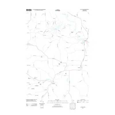
2013 Map of La Valle
USGS Topo · Published 2013About this map
Dutch Hollow Lake and its intricate residential network dominate the northern landscape, reflecting modern land use in this part of Wisconsin. Further south, the map reveals a legacy of agrarian settlement, characterized by numerous named agricultural operations such as the Lone Pine Stock Farm, Little Valley Dairy and Stock Farm, and Village View Stock Farm. These family and commercial farm labels provide a detailed record of land ownership and local industry in the valleys of the Little Baraboo River.
Find a feature on this map
102 named features on this map. Tap any name to fly to it.
Don’t see what you’re looking for? This feature index may not catch every label — zoom into the map to look around manually.
Map Details
Editions of this 2013 La Valle Map
This is the sole edition of this map. No revisions or reprints were ever made.
Other maps of this area

1905 · Richland Center
USGS Topo · 1:125,000

1927 · Hillsboro
USGS Topo · 1:62,500

1956 · Reedsburg
USGS Topo · 1:62,500

1958 · La Crosse
USGS Topo · 1:250,000

1960 · Richland Center
USGS Topo · 1:62,500

1960 · Plain
USGS Topo · 1:62,500

1961 · La Crosse
USGS Topo · 1:250,000

1965 · La Crosse
USGS Topo · 1:250,000

1966 · Hillsboro
USGS Topo · 1:62,500
1975 · Wonewoc
USGS Topo · 1:24,000