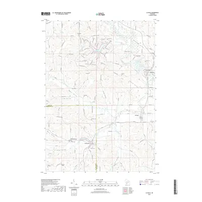
2018 Map of La Valle
USGS Topo · Published 2018About this map
Cazenovia and Ironton anchor the southern portion of this landscape, where the Richland Co Sauk Co line divides the terrain. The area is defined by a series of distinct valleys, including Quaker Valley, English Valley, and Welch Valley, which channel small waterways toward the Baraboo River and the Little Baraboo River. Near the settlement of La Valle, the river widens at the La Valle Mill Pond near the site of the La Valle Mill.
Find a feature on this map
129 named features on this map. Tap any name to fly to it.
Don’t see what you’re looking for? This feature index may not catch every label — zoom into the map to look around manually.
Map Details
Editions of this 2018 La Valle Map
This is the sole edition of this map. No revisions or reprints were ever made.
Other maps of this area

1905 · Richland Center
USGS Topo · 1:125,000

1927 · Hillsboro
USGS Topo · 1:62,500

1956 · Reedsburg
USGS Topo · 1:62,500

1958 · La Crosse
USGS Topo · 1:250,000

1960 · Richland Center
USGS Topo · 1:62,500

1960 · Plain
USGS Topo · 1:62,500

1961 · La Crosse
USGS Topo · 1:250,000

1965 · La Crosse
USGS Topo · 1:250,000

1966 · Hillsboro
USGS Topo · 1:62,500
1975 · Wonewoc
USGS Topo · 1:24,000