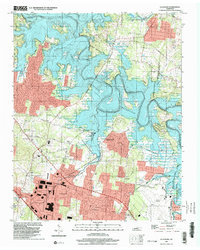
1997 Map of La Vergne
USGS Topo · Published 2002About this map
La Vergne and the surrounding Rutherford and Davidson County borderlands are defined by the expansive waters of the J Percy Priest Reservoir in the late 1990s. This survey illustrates a landscape where suburban growth and recreation areas meet established rural landmarks. The inundation of the Stones River valley is central to the area's layout, creating a shoreline punctuated by the Long Hunter State Park and the Hurricane Creek Recreation Area.
Find a feature on this map
61 named features on this map. Tap any name to fly to it.
Don’t see what you’re looking for? This feature index may not catch every label — zoom into the map to look around manually.
Map Details
Editions of this 1997 La Vergne Map
This is the sole edition of this map. No revisions or reprints were ever made.
Other maps of this area

1903 · Nashville
USGS Topo · 1:125,000

1916 · Murfreesboro
USGS Topo · 1:62,500

1932 · Hermitage
USGS Topo · 1:62,500

1942 · Lebanon
USGS Topo · 1:100,000

1950 · Walterhill
USGS Topo · 1:24,000

1951 · Martha
USGS Topo · 1:24,000

1952 · Hermitage
USGS Topo · 1:24,000

1952 · La Vergne
USGS Topo · 1:24,000

1952 · Nashville East
USGS Topo · 1:24,000

1952 · Antioch
USGS Topo · 1:24,000