
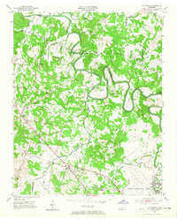
1952 Map of La Vergne
USGS Topo · Published 1954About this map
Stones River winds through a landscape of agrarian settlements and growing infrastructure in this early 1950s survey of the Davidson and Rutherford county border. The village of La Vergne sits along the Nashville Chattanooga and St Louis railway, serving as a focal point for the surrounding rural community. To the southeast, the expansive grounds of Sewart Air Force Base mark a significant military presence in the post-war era, contrasting with the scattered family homes and small crossroads like Smith Springs and Four Corners.
Find a feature on this map
54 named features on this map. Tap any name to fly to it.
Don’t see what you’re looking for? This feature index may not catch every label — zoom into the map to look around manually.
Map Details
Editions of this 1952 La Vergne Map
2 editions found
Other maps of this area

1903 · Nashville
USGS Topo · 1:125,000

1916 · Murfreesboro
USGS Topo · 1:62,500

1932 · Hermitage
USGS Topo · 1:62,500

1942 · Lebanon
USGS Topo · 1:100,000

1950 · Walterhill
USGS Topo · 1:24,000

1951 · Martha
USGS Topo · 1:24,000

1952 · Hermitage
USGS Topo · 1:24,000

1952 · Nashville East
USGS Topo · 1:24,000

1952 · Antioch
USGS Topo · 1:24,000

1956 · Gladeville
USGS Topo · 1:24,000