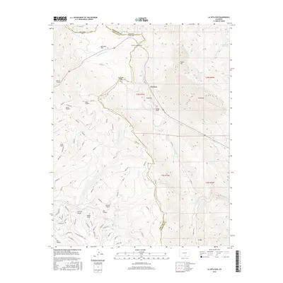
2016 Map of La Veta Pass
USGS Topo · Published 2016About this map
La Veta Pass and North La Veta Pass serve as the primary gateways through the high country where the boundaries of Huerfano and Costilla counties converge. This mountain landscape is defined by its strategic corridors, notably the path through the Muleshoe area and the ascent past Windy Point. The map details a complex network of high-altitude water sources including Yellowstone Reservoir and the headwaters of Sangre de Cristo Cr. Distinctive landforms such as Mt Mestas, Dump Mtn, and Rough Mtn dominate the topography, while numerous named canyons like Mexican Canyon and Toll Canyon cut through the terrain. To the south, the settlement at Codo sits near the winding S Middle Cr, illustrating the relationship between the few level flats like McDowell Park and the surrounding peaks.
Find a feature on this map
82 named features on this map. Tap any name to fly to it.
Don’t see what you’re looking for? This feature index may not catch every label — zoom into the map to look around manually.
Map Details
Editions of this 2016 La Veta Pass Map
This is the sole edition of this map. No revisions or reprints were ever made.
Other maps of this area

1889 · Huerfano Park
USGS Topo · 1:125,000

1892 · Huerfano Park
USGS Topo · 1:125,000

1954 · Trinidad
USGS Topo · 1:250,000

1955 · Trinidad
USGS Topo · 1:250,000

1958 · Trinidad
USGS Topo · 1:250,000

1959 · Trinidad
USGS Topo · 1:250,000

1963 · Mc Carty Park
USGS Topo · 1:24,000

1963 · La Veta Pass
USGS Topo · 1:24,000
1963 · La Veta
USGS Topo · 1:24,000
1963 · Cuchara
USGS Topo · 1:24,000