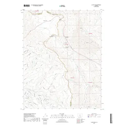
2019 Map of La Veta Pass
USGS Topo · Published 2019About this map
La Veta Pass serves as the central high-altitude crossing on this 2019 survey, marking the transition between Huerfano Co and Costilla Co. This modern topographic study reveals a landscape defined by significant elevation changes, from the heights of Mt Mestas and Rough Mtn to the deep incisions of Mexican Canyon and Toll Canyon. The map documents a complex network of mountain roads and private lanes, such as Co RD 443 and Emery Loop, which connect the small settlement at Muleshoe with the broader alpine terrain. Multiple historic crossings are mapped in detail, including North La Veta Pass, Pass Creek Pass, and Sangre de Cristo Pass. In the southern portion of the sheet, the geography levels slightly at Wagon Mesa before dropping into Fox Canyon near the area of Codo. This record of the Sangre de Cristo foothills provides essential data on contemporary land use and mountain access routes.
Find a feature on this map
83 named features on this map. Tap any name to fly to it.
Don’t see what you’re looking for? This feature index may not catch every label — zoom into the map to look around manually.
Map Details
Editions of this 2019 La Veta Pass Map
This is the sole edition of this map. No revisions or reprints were ever made.
Other maps of this area

1889 · Huerfano Park
USGS Topo · 1:125,000

1892 · Huerfano Park
USGS Topo · 1:125,000

1954 · Trinidad
USGS Topo · 1:250,000

1955 · Trinidad
USGS Topo · 1:250,000

1958 · Trinidad
USGS Topo · 1:250,000

1959 · Trinidad
USGS Topo · 1:250,000

1963 · Mc Carty Park
USGS Topo · 1:24,000

1963 · La Veta Pass
USGS Topo · 1:24,000
1963 · La Veta
USGS Topo · 1:24,000
1963 · Cuchara
USGS Topo · 1:24,000