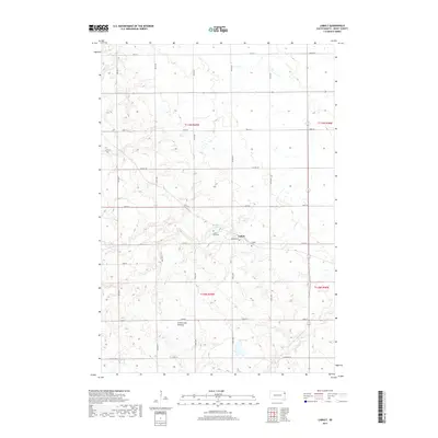
2017 Map of LaBolt
USGS Topo · Published 2017About this map
LaBolt occupies a central position on the rolling uplands of the Coteau des Prairies, a vast plateau that dominates the landscape of Grant County. This agricultural region is defined by its regular section grid and a scattering of natural water features, including LaBolt Lake and the marshy expanse of Mud Lake. Local history and genealogy are anchored by the presence of the LaBolt Cem and the specific LaBolt Gravesite located just west of the town center. The drainage of the area is marked by the winding course of the S Fork Yellow Bank River, which meanders through the southeastern portion of the map. This survey provides a modern view of the rural road network, from local thoroughfares like Georgia Ave to regional routes such as E Co Hwy 20 and Co Hwy 28.
Find a feature on this map
21 named features on this map. Tap any name to fly to it.
Don’t see what you’re looking for? This feature index may not catch every label — zoom into the map to look around manually.
Map Details
Editions of this 2017 LaBolt Map
This is the sole edition of this map. No revisions or reprints were ever made.
Other maps of this area

1953 · Milbank
USGS Topo · 1:250,000

1953 · Watertown
USGS Topo · 1:250,000

1958 · Milbank
USGS Topo · 1:250,000

1958 · Watertown
USGS Topo · 1:250,000

1970 · Goodwin
USGS Topo · 1:24,000

1973 · Twin Brooks
USGS Topo · 1:24,000

1973 · LaBolt
USGS Topo · 1:24,000

1973 · Tunerville
USGS Topo · 1:24,000
1973 · Milbank West
USGS Topo · 1:24,000

1973 · Stockholm
USGS Topo · 1:24,000