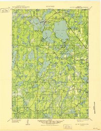
1951 Map of Lac Du Flambeau
USGS Topo · Published 1951About this map
Lac du Flambeau serves as the focal point of this northern Wisconsin landscape, characterized by a complex network of interconnected glacial lakes and dense woodlands within the Northern Highland State Forest. The map documents a period when the Chicago and Northwestern railroad provided critical access to this remote region, stopping at Lac du Flambeau Sta and passing near the Flambeau Fire Tower. The settlement pattern is concentrated around major water bodies like Pokegama Lake and Long Interlaken Lake, while the outlying areas remain dominated by smaller, often family-named waters such as Ross Allen Lake and Bills Lake. Local infrastructure is visible at the Marlands Sch and the small settlement of Marlands, illustrating the modest development of the Oneida and Vilas county borderlands during the mid-century.
Find a feature on this map
89 named features on this map. Tap any name to fly to it.
Don’t see what you’re looking for? This feature index may not catch every label — zoom into the map to look around manually.
Map Details
Editions of this 1951 Lac Du Flambeau Map
This is the sole edition of this map. No revisions or reprints were ever made.
Other maps of this area

1938 · Minocqua
USGS Topo · 1:48,000

1938 · Lac Du Flambeau
USGS Topo · 1:48,000

1939 · Trout Lake
USGS Topo · 1:48,000

1939 · Lac Du Flambeau
USGS Topo · 1:48,000

1939 · Mc Cord
USGS Topo · 1:48,000

1939 · Winchester
USGS Topo · 1:48,000

1939 · Cassian
USGS Topo · 1:48,000

1940 · Mercer
USGS Topo · 1:48,000

1941 · Pike Lake
USGS Topo · 1:48,000

1941 · Brantwood
USGS Topo · 1:48,000