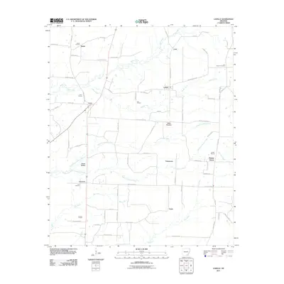
2011 Map of Ladelle
USGS Topo · Published 2011About this map
Goose Hollow and Prairie Grove anchor this portion of Drew County, where the landscape is defined by the headwaters of numerous small waterways. A series of timber-related and local travel routes, such as Wilmar Tram Rd, Ladelle Rd, and Van Horn Loop, crisscross the territory, connecting several small rural communities including Valley Junction, Lacey, and Carpenter. The presence of numerous family and community burial grounds, such as Beulah Cemetery and Lone Sassafras Cemetery, suggests a long-settled rural history across the Long Prairie terrain. The map's drainage pattern is complex, featuring the branching of North Fork Panther Creek, South Fork Panther Creek, and Bear Creek, which flow through a grid of county roads that continue to define the agricultural and residential layout of this Arkansas region.
Find a feature on this map
74 named features on this map. Tap any name to fly to it.
Don’t see what you’re looking for? This feature index may not catch every label — zoom into the map to look around manually.
Map Details
Editions of this 2011 Ladelle Map
This is the sole edition of this map. No revisions or reprints were ever made.
Other maps of this area

1935 · Mist
USGS Topo · 1:62,500

1935 · Cominto
USGS Topo · 1:62,500

1952 · Fountain Hill
USGS Topo · 1:24,000

1953 · Greenwood
USGS Topo · 1:250,000

1956 · Greenwood
USGS Topo · 1:250,000

1960 · Mist
USGS Topo · 1:62,500

1960 · Collins
USGS Topo · 1:62,500
1960 · Mist
USGS Topo · 1:24,000

1960 · Cominto
USGS Topo · 1:24,000
1960 · Mist NW
USGS Topo · 1:24,000