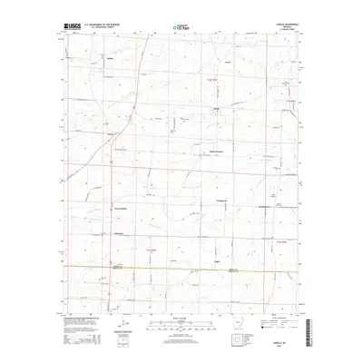
2014 Map of Ladelle
USGS Topo · Published 2014About this map
Goose Hollow and the surrounding timberlands of Southeast Arkansas define this topography along the border of Drew Co and Ashley Co. The map reveals a landscape organized by late 20th-century rural infrastructure, where small settlements like Ladelle, Youngstown, and Carpenter are linked by a network of local roads including Goose Hollow Rd and Jogger Rd. The terrain is characterized by a series of north-south flowing watercourses such as Jumper Cr, N Fork Panther Cr, and S Fork Panther Cr, which drain the area's flatwoods. Genealogists will find particular value in the distribution of family-named sites and burial grounds, such as Lone Sassafras Cem, Deal Cem, and Gray Cem, which provide anchors for local family histories in this part of the state.
Find a feature on this map
89 named features on this map. Tap any name to fly to it.
Don’t see what you’re looking for? This feature index may not catch every label — zoom into the map to look around manually.
Map Details
Editions of this 2014 Ladelle Map
This is the sole edition of this map. No revisions or reprints were ever made.
Other maps of this area

1935 · Mist
USGS Topo · 1:62,500

1935 · Cominto
USGS Topo · 1:62,500

1952 · Fountain Hill
USGS Topo · 1:24,000

1953 · Greenwood
USGS Topo · 1:250,000

1956 · Greenwood
USGS Topo · 1:250,000

1960 · Mist
USGS Topo · 1:62,500

1960 · Collins
USGS Topo · 1:62,500
1960 · Mist
USGS Topo · 1:24,000

1960 · Cominto
USGS Topo · 1:24,000
1960 · Mist NW
USGS Topo · 1:24,000