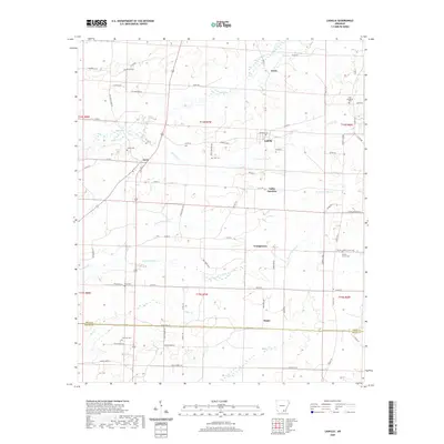
2020 Map of Ladelle
USGS Topo · Published 2020About this map
The boundary between Drew and Ashley counties is defined by a network of creeks and small settlements in this 2020 Arkansas landscape. Lacey and Ladelle anchor the northern reaches, connected by rural routes such as Co Rd 28 and Michigan Ave. The area is notably dense with small family or community burial grounds, including Lone Sassafras Cem, Beulah Cem, and Prairie Grove Cem, which suggest a long history of local settlement despite the modern topography. Waterways like Jumper Cr and the various forks of Panther Cr dictate the layout of the land, while southern hamlets such as Scipio and Youngstown sit among the headwaters of Bear Cr and Flat Cr. This map offers a clear view of the rural road network, from established county roads to more specialized paths like Gates Mainline Rd.
Find a feature on this map
79 named features on this map. Tap any name to fly to it.
Don’t see what you’re looking for? This feature index may not catch every label — zoom into the map to look around manually.
Map Details
Editions of this 2020 Ladelle Map
This is the sole edition of this map. No revisions or reprints were ever made.
Other maps of this area

1935 · Mist
USGS Topo · 1:62,500

1935 · Cominto
USGS Topo · 1:62,500

1952 · Fountain Hill
USGS Topo · 1:24,000

1953 · Greenwood
USGS Topo · 1:250,000

1956 · Greenwood
USGS Topo · 1:250,000

1960 · Mist
USGS Topo · 1:62,500

1960 · Collins
USGS Topo · 1:62,500
1960 · Mist
USGS Topo · 1:24,000

1960 · Cominto
USGS Topo · 1:24,000
1960 · Mist NW
USGS Topo · 1:24,000