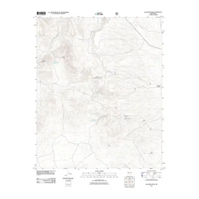
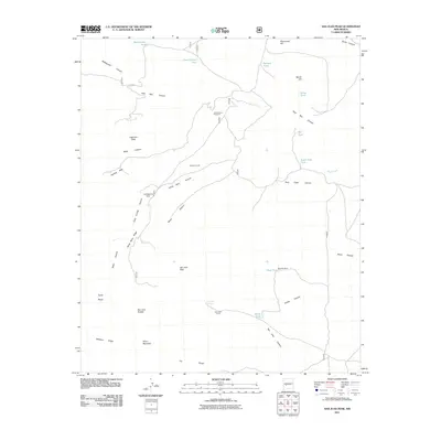
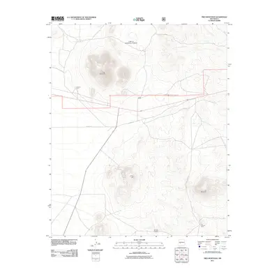
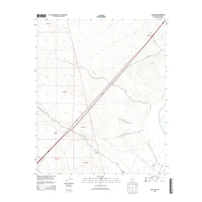
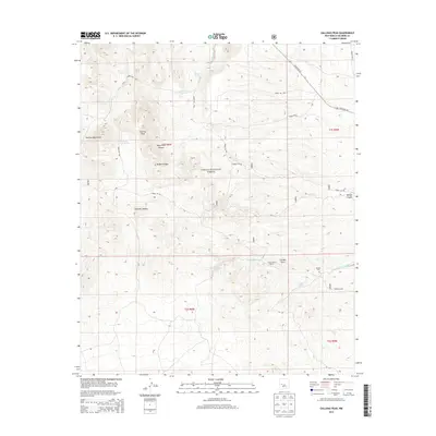
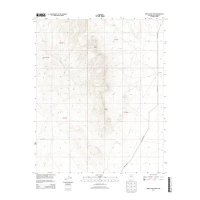
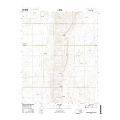
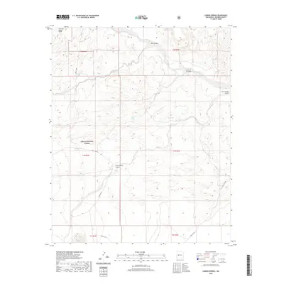
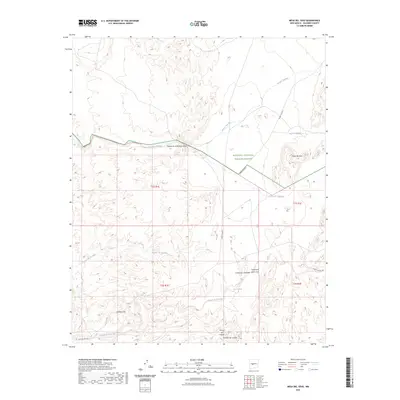
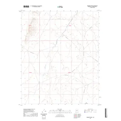
1985 Map of Ladron Peak
USGS Topo · Published 1985About this map
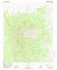
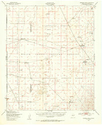
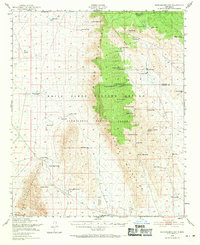
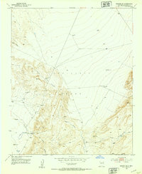
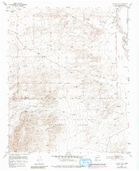
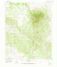
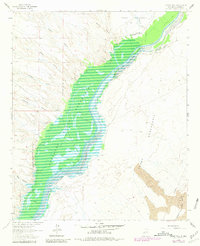
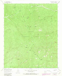
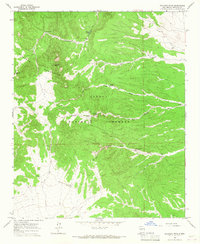
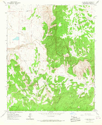
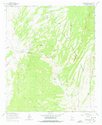
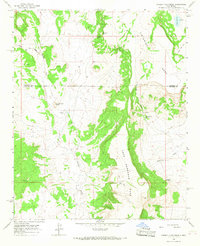
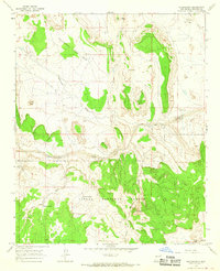
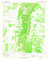
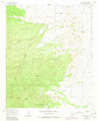
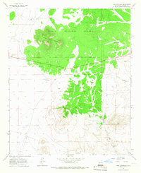
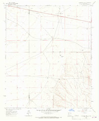
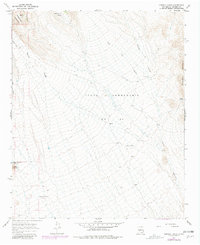
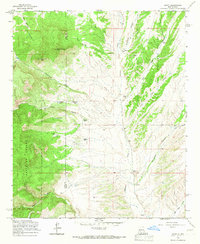
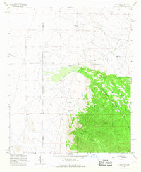
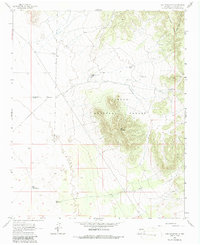
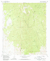
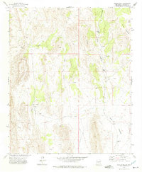
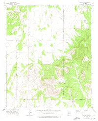
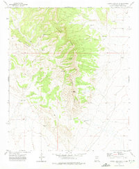
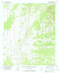
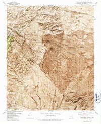
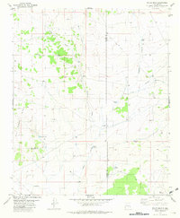
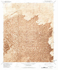
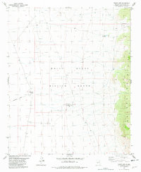
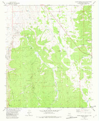
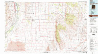
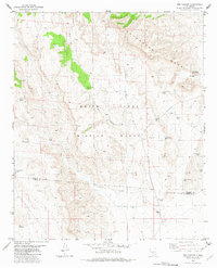
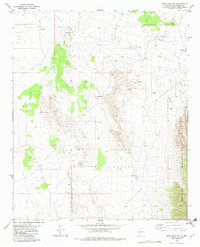
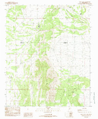
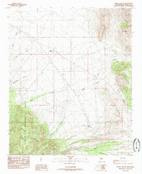
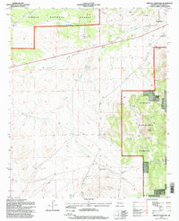
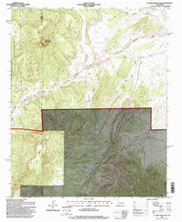
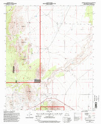
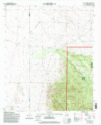
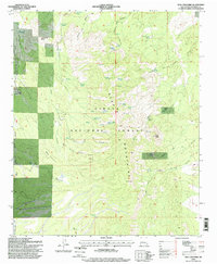
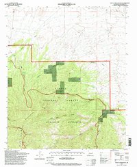
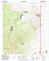
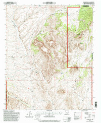
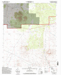
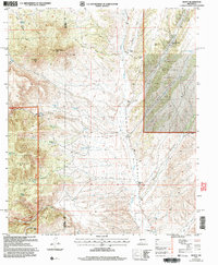
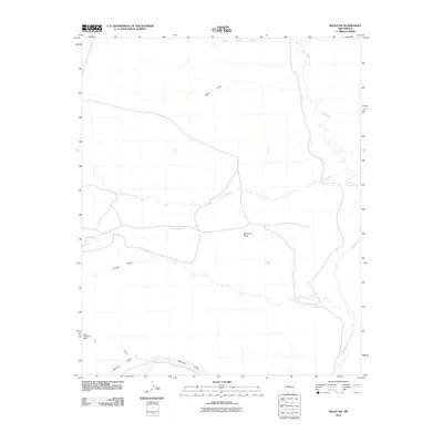
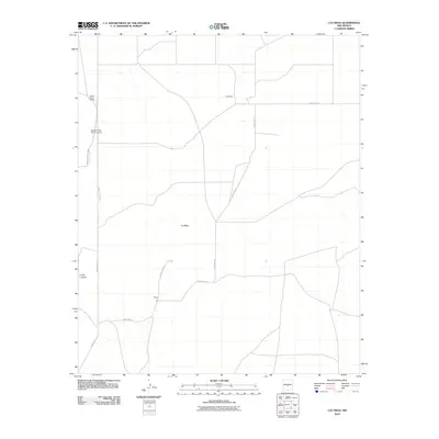
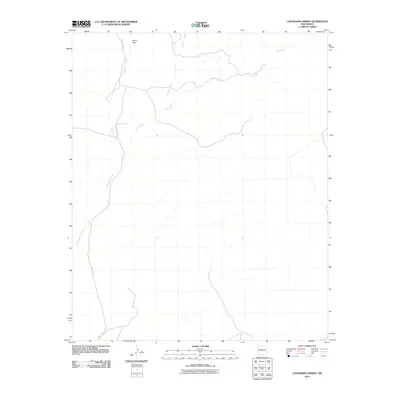
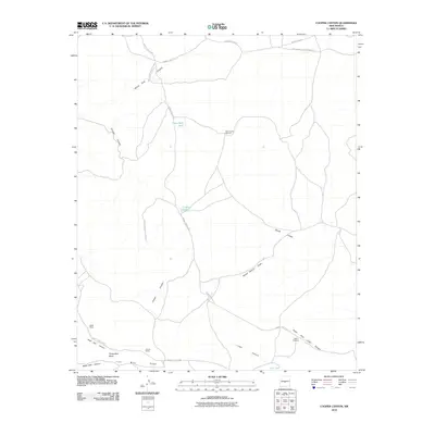
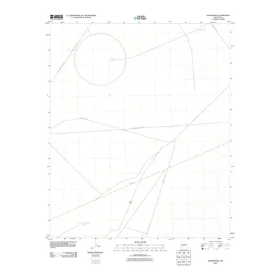
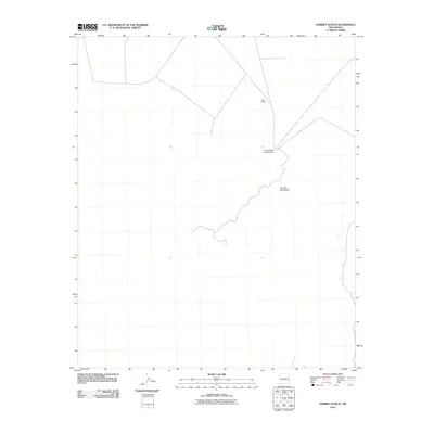
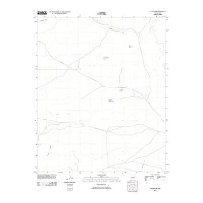
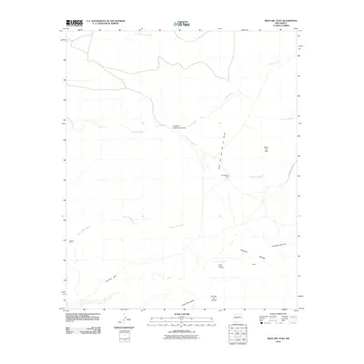
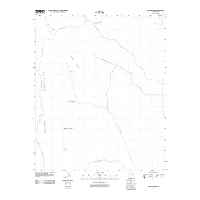
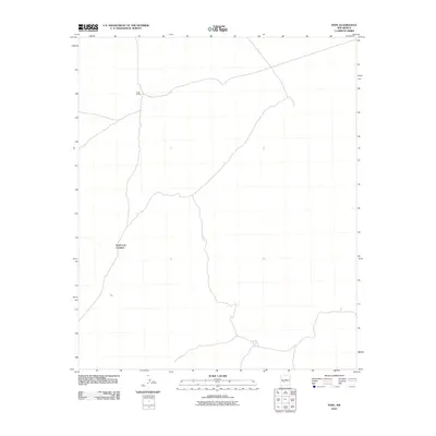
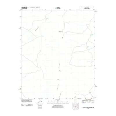
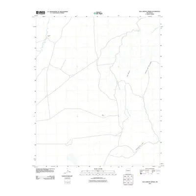
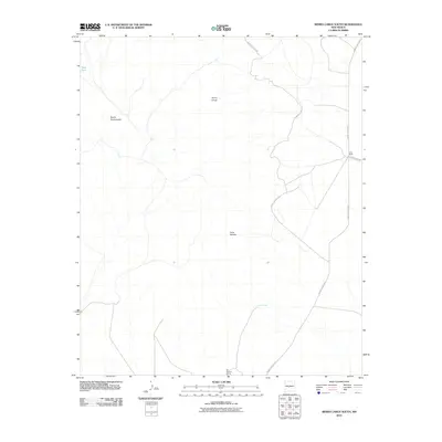
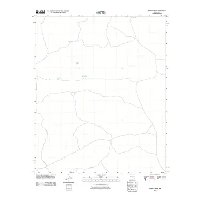
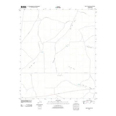
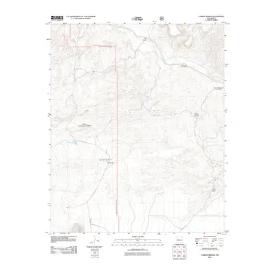
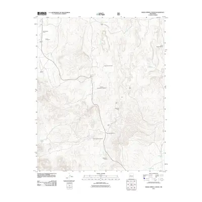
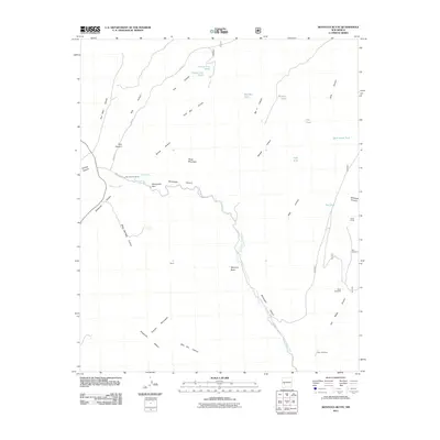
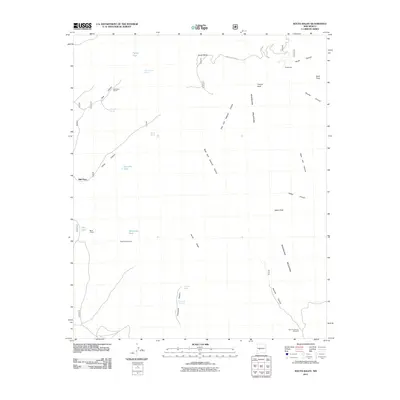
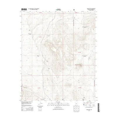
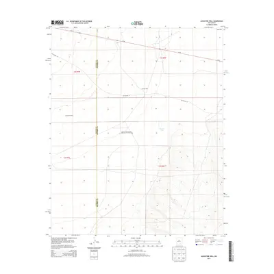
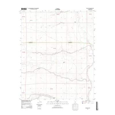
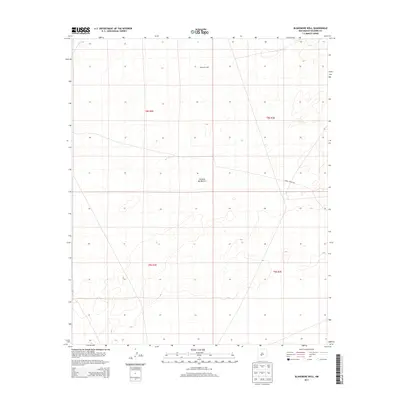
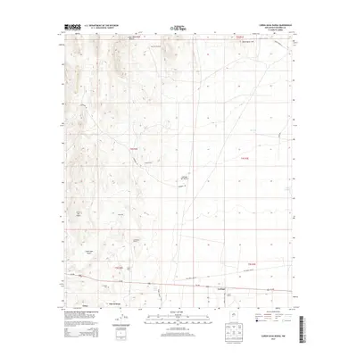
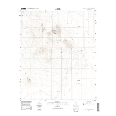
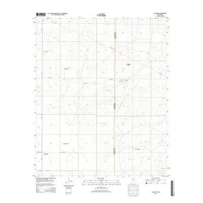
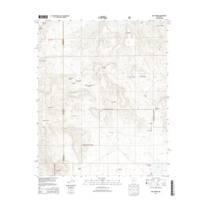
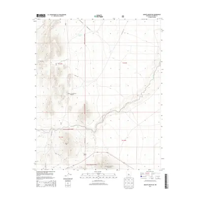
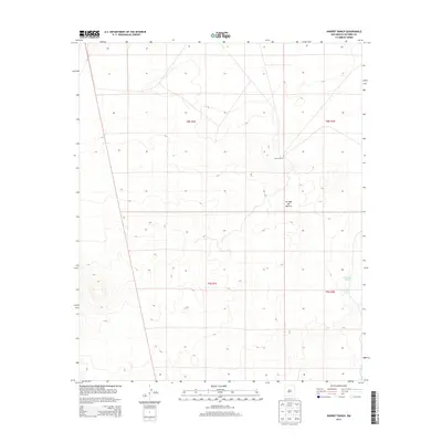
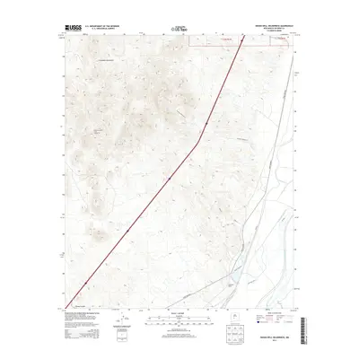
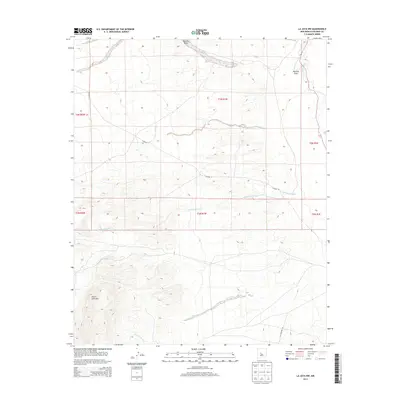
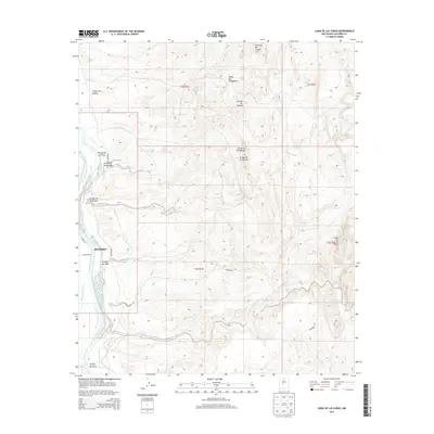
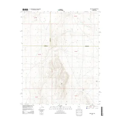
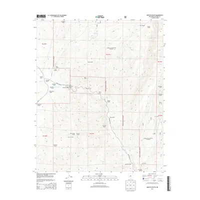
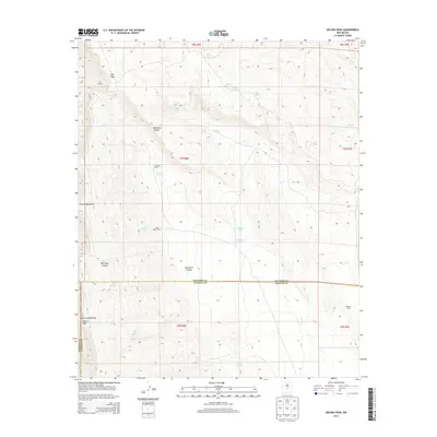
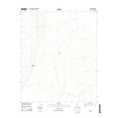
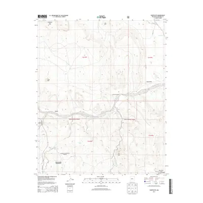
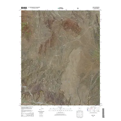
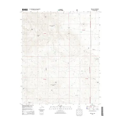
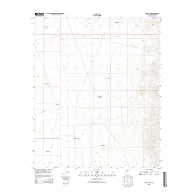
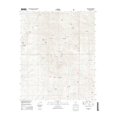
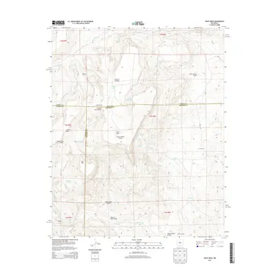
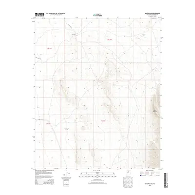
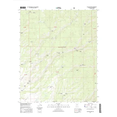
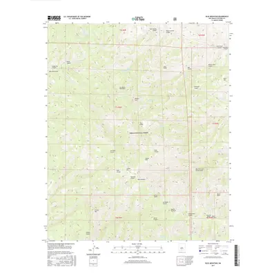
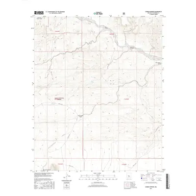
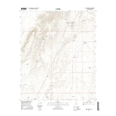
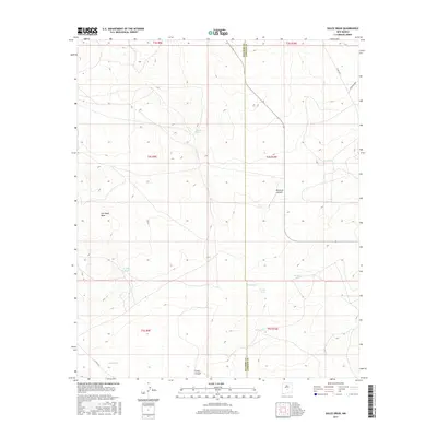
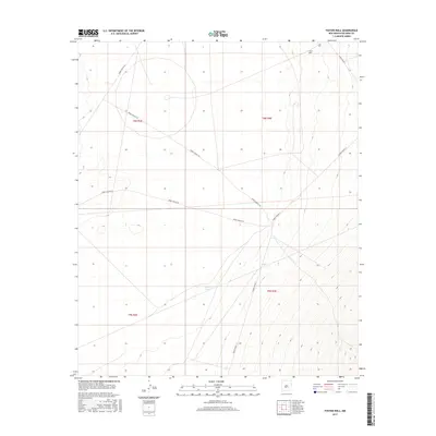
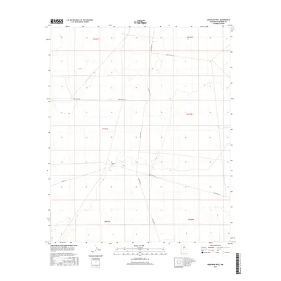
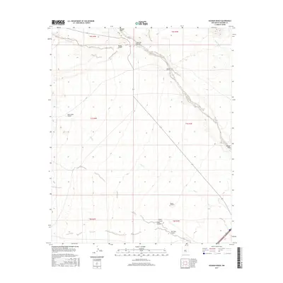
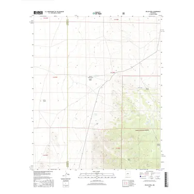
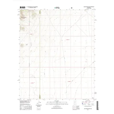
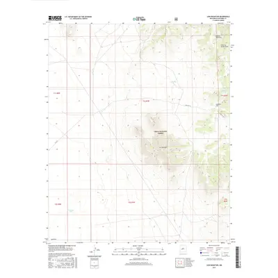
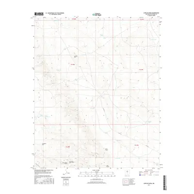
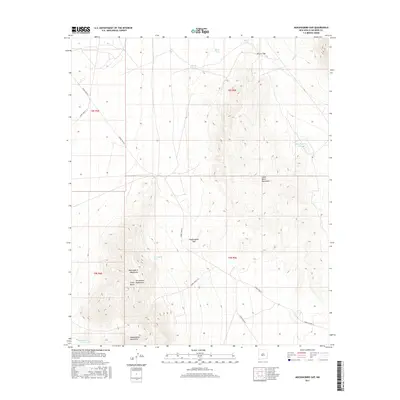
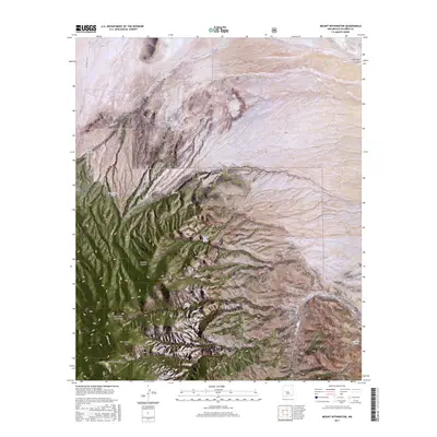
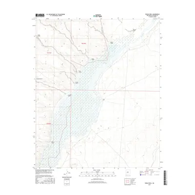
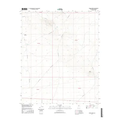
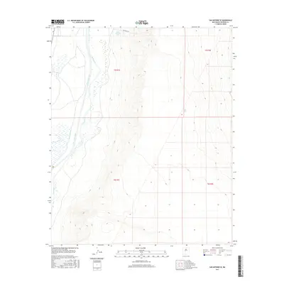
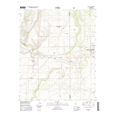
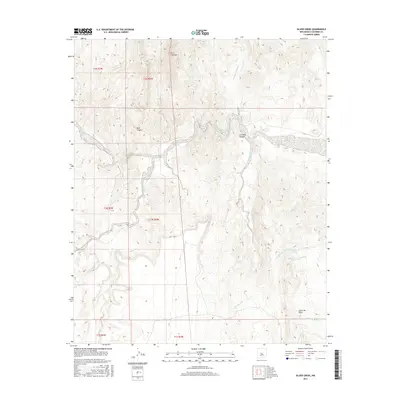
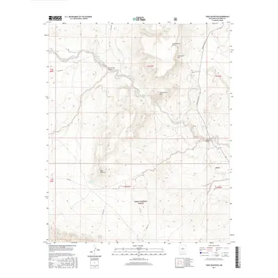
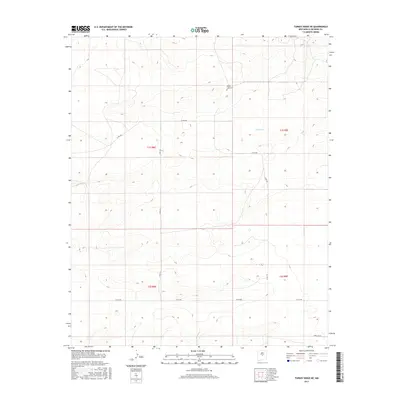
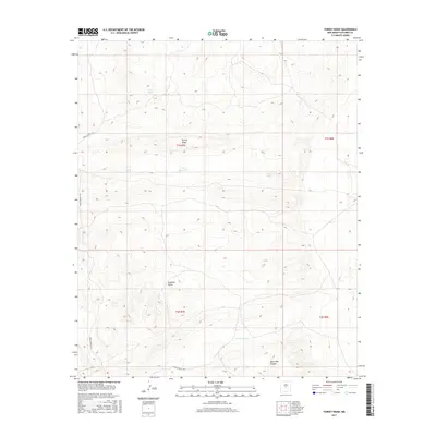
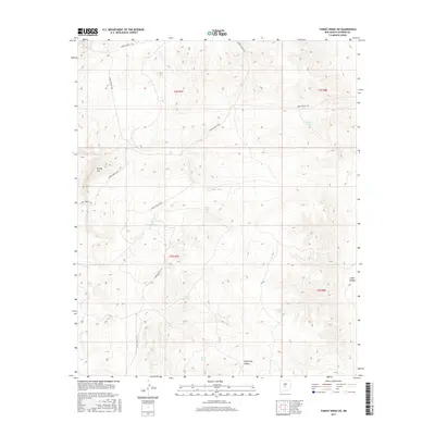
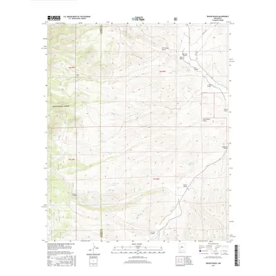
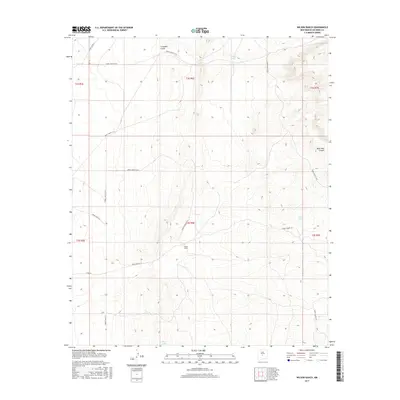
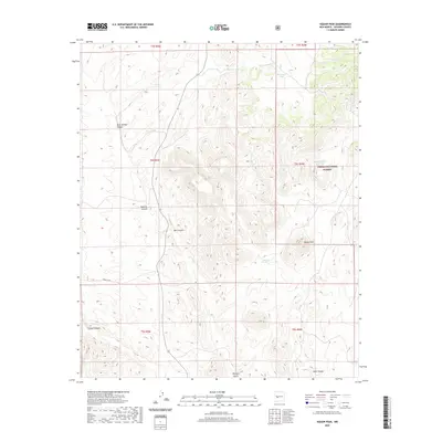
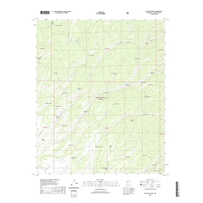
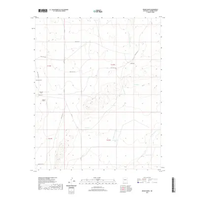
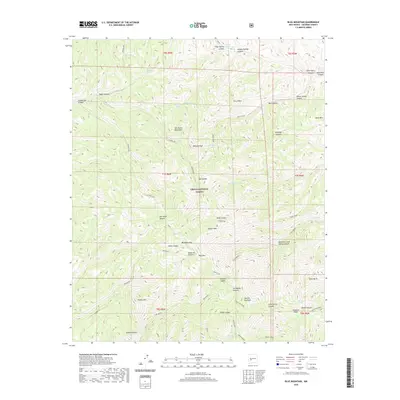
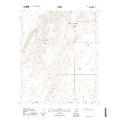
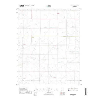
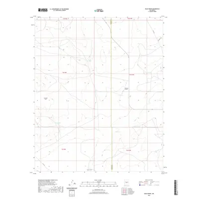
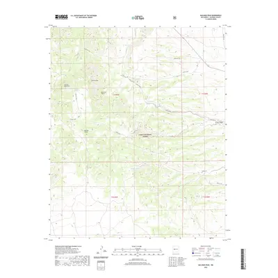
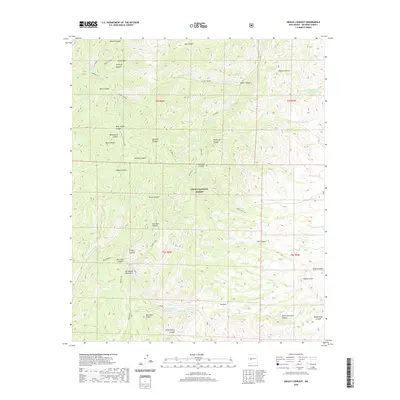
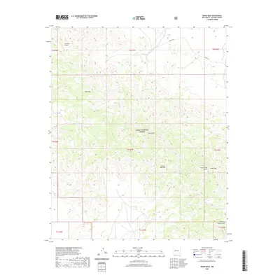
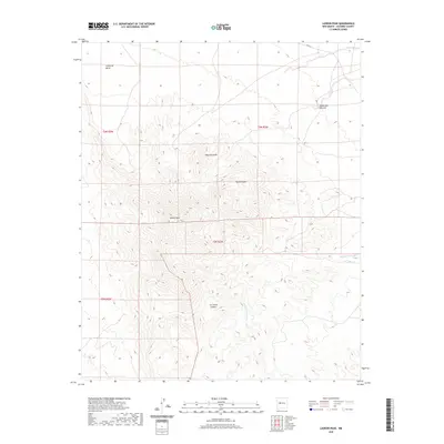
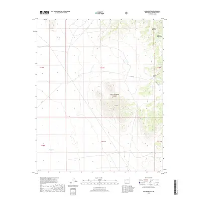
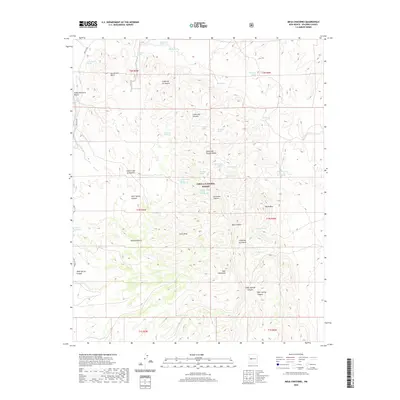
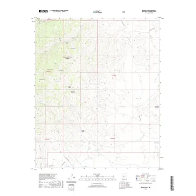
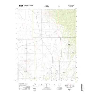
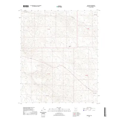
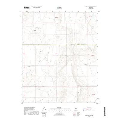
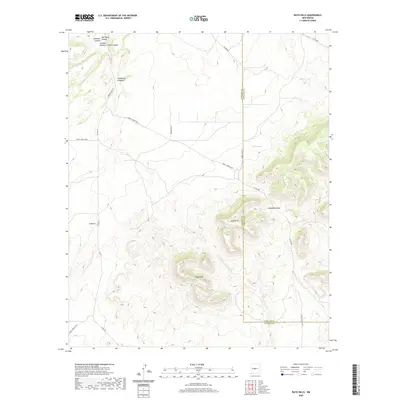
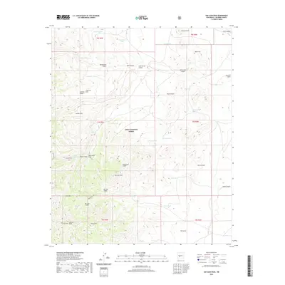
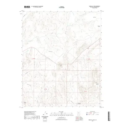
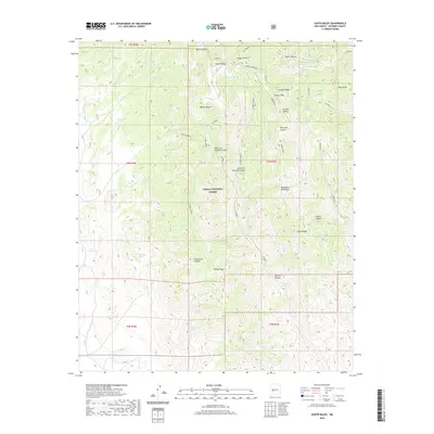
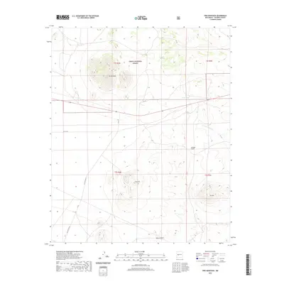
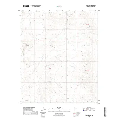
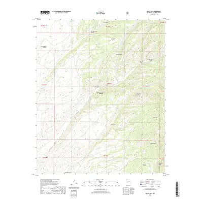
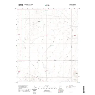
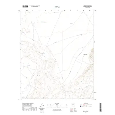
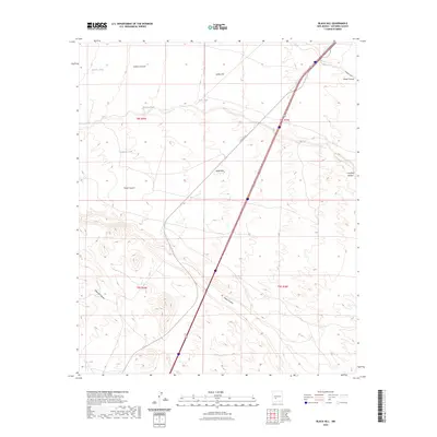
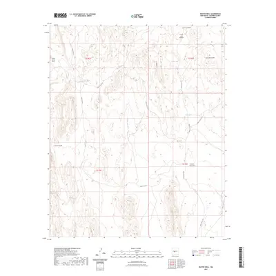
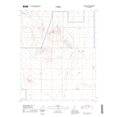
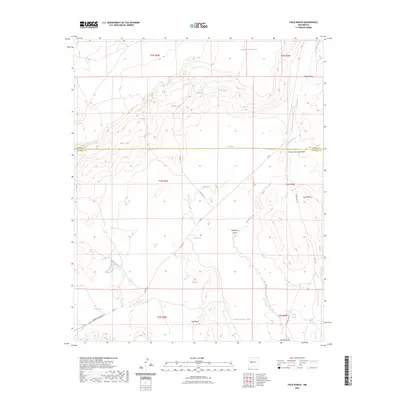
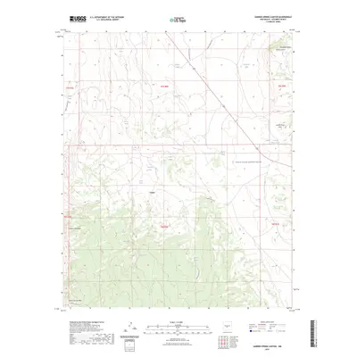
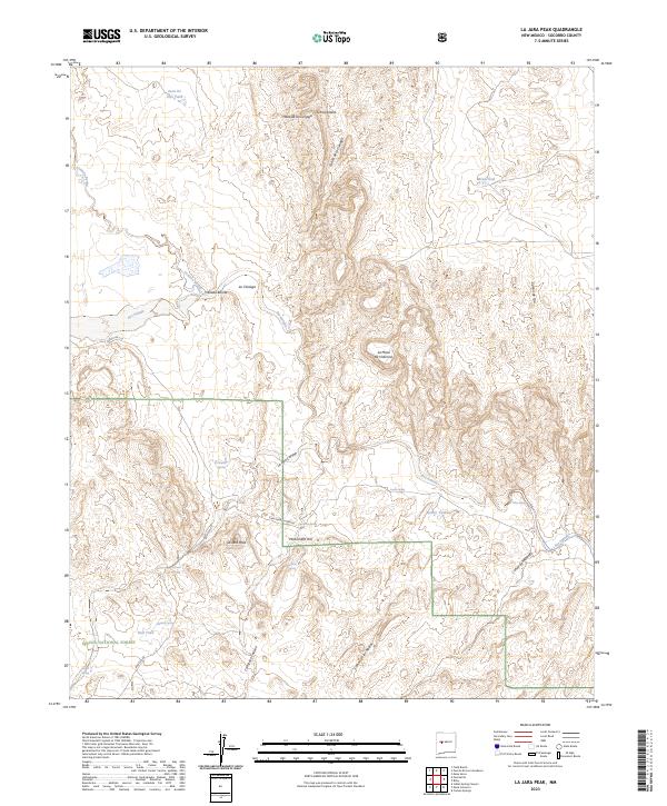
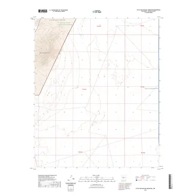
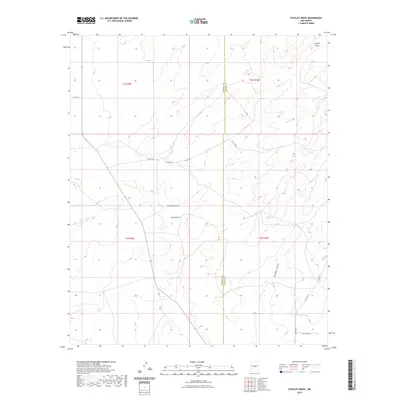
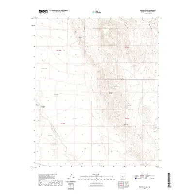
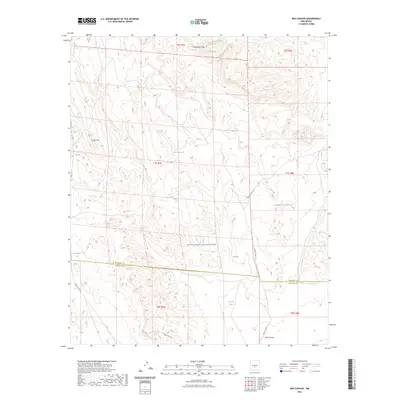
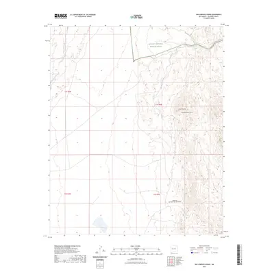
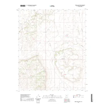
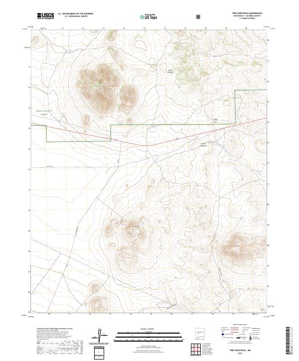
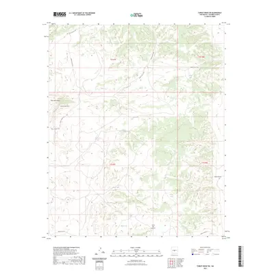
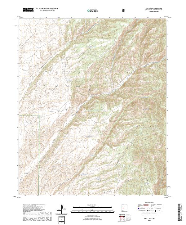
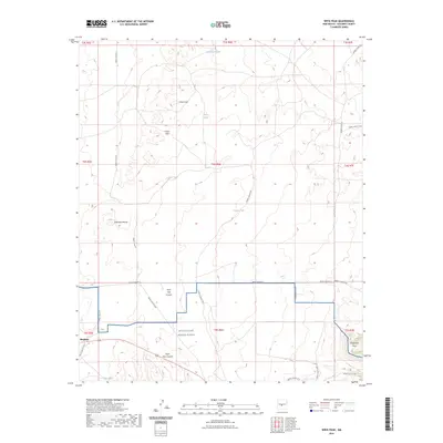
Ladron Peak dominates this 1985 provisional study, rising as a prominent focal point in Socorro County. The landscape is defined by the Sevilleta National Wildlife Refuge and Grant Boundary, which encompasses much of the southern and eastern portions of the quadrangle. This area preserves a complex system of drainage and relief, where major incisions like Cañon del Norte and Cañon del Mariano cut through the high ground. To the south, Monte Negro stands near the edge of the refuge, overlooking a network of seasonal watercourses including Cueva Canyon and Mule Canyon. The lack of established towns or paved roads reflects the protected and primitive nature of this terrain during the mid-1980s, with only a scattered Jeep Trail providing limited access through the backcountry.
Find a feature on this map
12 named features on this map. Tap any name to fly to it.
Don’t see what you’re looking for? This feature index may not catch every label — zoom into the map to look around manually.
Map Details
Editions of this 1985 Ladron Peak Map
This is the sole edition of this map. No revisions or reprints were ever made.
Historical Maps of Socorro County Through Time
675 maps found

1918 Oscura Peak
Socorro County, NM
1948 Bingham
Socorro County, NM
1948 Broken Back Crater
Socorro County, NM
1948 Carthage
Socorro County, NM
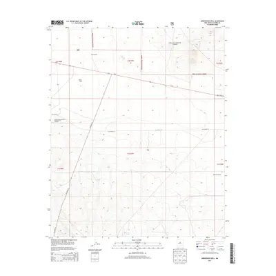
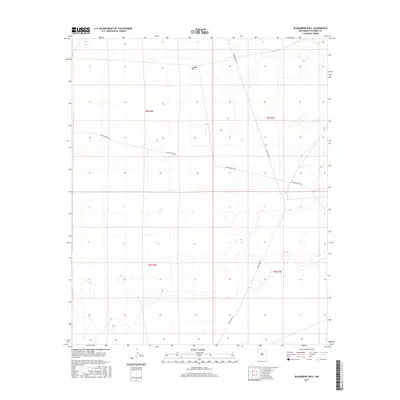
1948 Granjean Well
Socorro County, NM
1948 Mockingbird Gap
Socorro County, NM
1948 Val Verde
Socorro County, NM
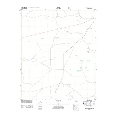
1952 Becker
Socorro County, NM
1952 Becker SW
Socorro County, NM
1952 Belen SW
Socorro County, NM
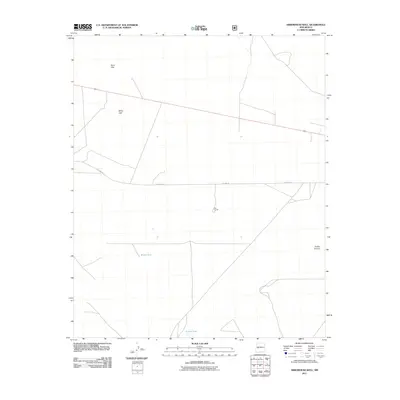
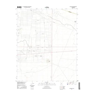
1952 Black Butte
Socorro County, NM
1952 Cerro Montoso
Socorro County, NM
1952 La Joya NW
Socorro County, NM
1952 San Anacia
Socorro County, NM
1959 Loma De Las Canas
Socorro County, NM
1959 Mesa Del Yeso
Socorro County, NM
1959 Riley
Socorro County, NM
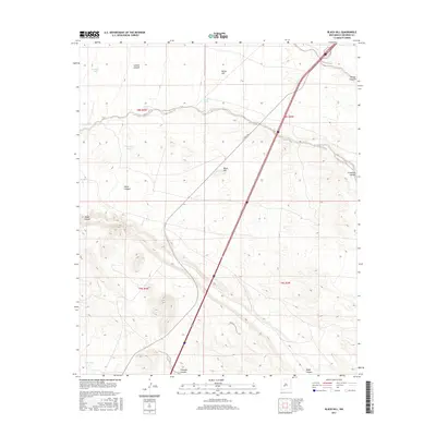
1961 Black Hill
Socorro County, NM
1961 Fort Craig
Socorro County, NM
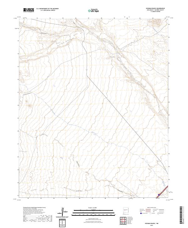
1961 Hickman Ranch
Socorro County, NM
1961 Paraje Well
Socorro County, NM
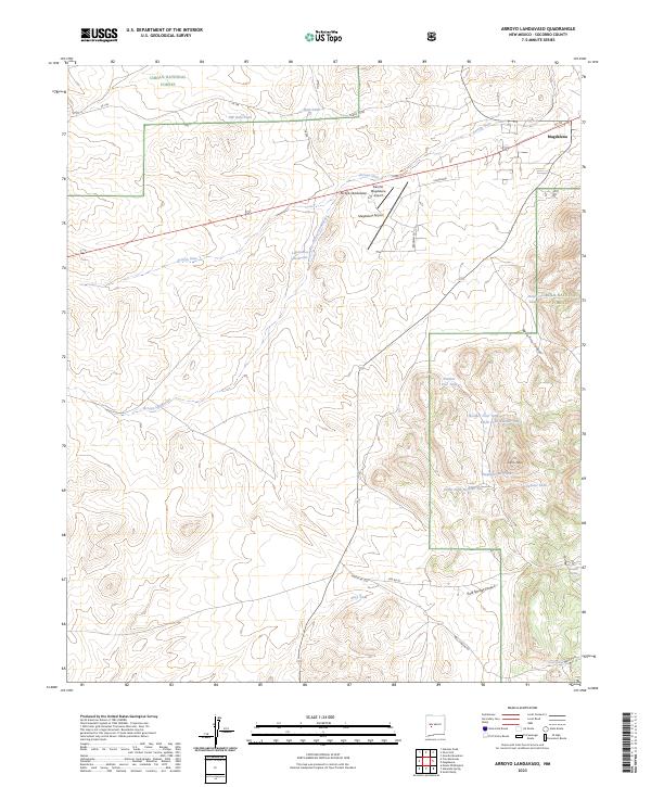
1963 Arroyo Landavaso
Socorro County, NM
1964 Arrowhead Well
Socorro County, NM
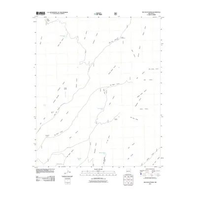
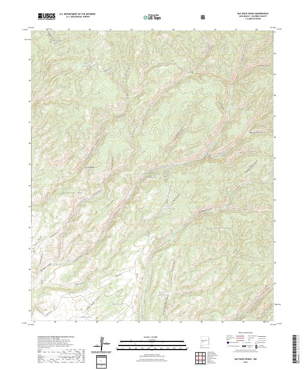
1964 Bay Buck Peaks
Socorro County, NM
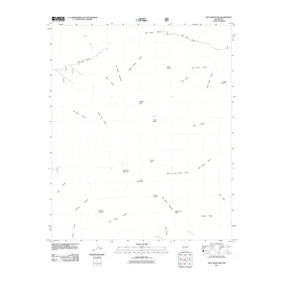
1964 Blue Mountain
Socorro County, NM
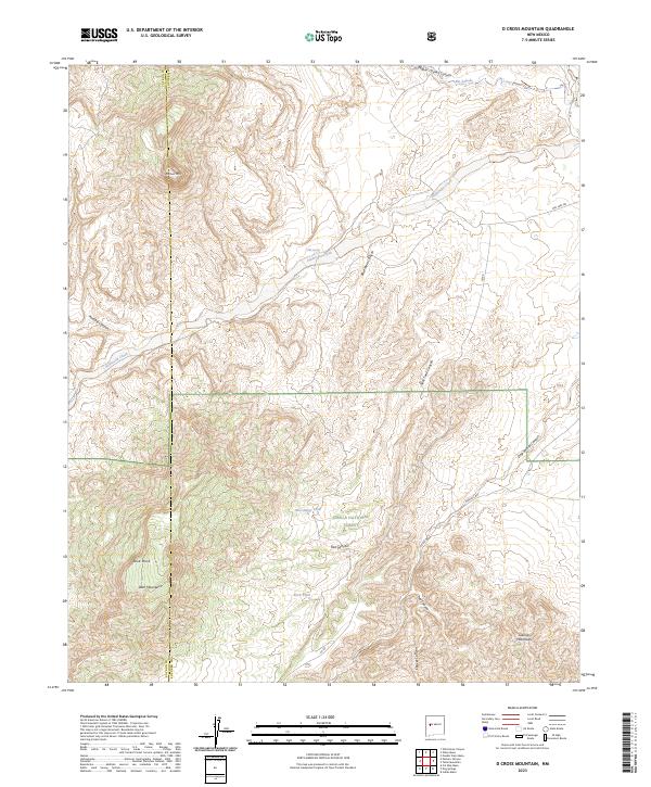
1964 D Cross Mountain
Socorro County, NM
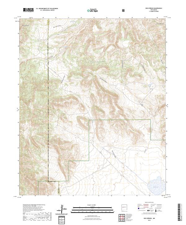
1964 Dog Springs
Socorro County, NM
1964 Field Ranch
Socorro County, NM
1964 Gallinas Peak
Socorro County, NM
1964 Grassy Lookout
Socorro County, NM
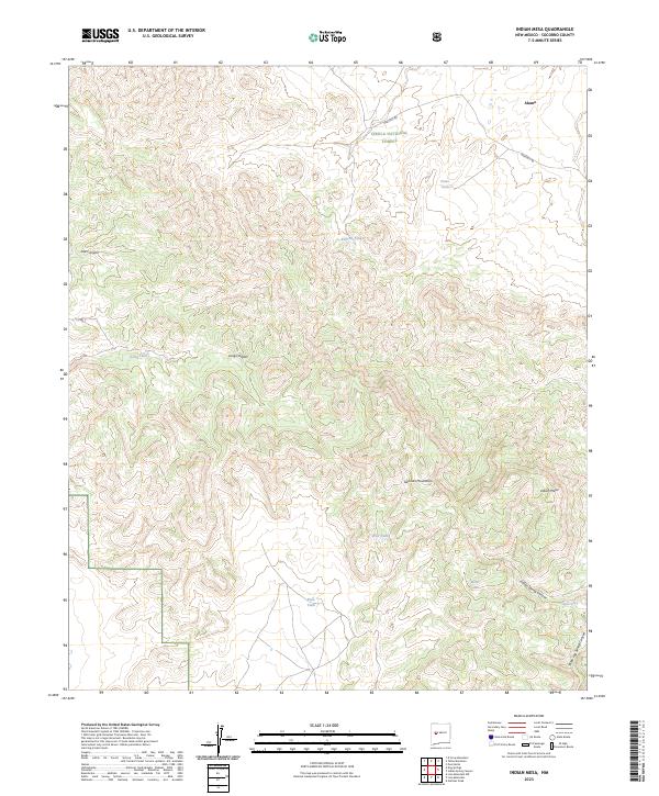
1964 Indian Mesa
Socorro County, NM
1964 Indian Spring Canyon
Socorro County, NM
1964 La Jara Peak
Socorro County, NM
1964 Lion Mountain
Socorro County, NM
1964 Mesa Cencerro
Socorro County, NM
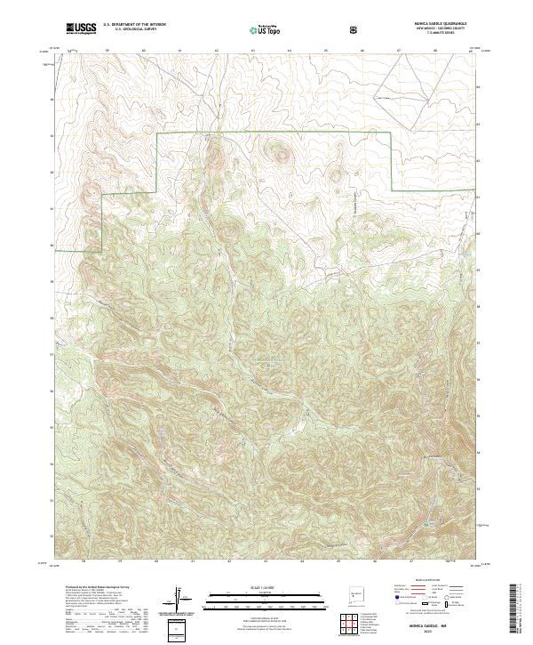
1964 Monica Saddle
Socorro County, NM
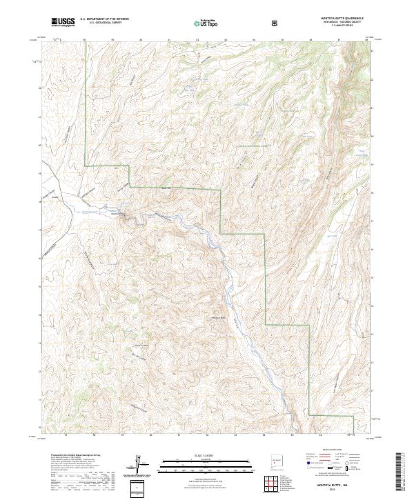
1964 Montoya Butte
Socorro County, NM
1964 Pueblo Viejo Mesa
Socorro County, NM
1964 Puertecito
Socorro County, NM
1964 Puerto De Los Cavadores
Socorro County, NM
1964 San Juan Peak
Socorro County, NM
1964 Silver Hill
Socorro County, NM
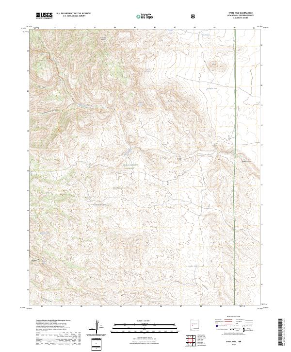
1964 Steel Hill
Socorro County, NM
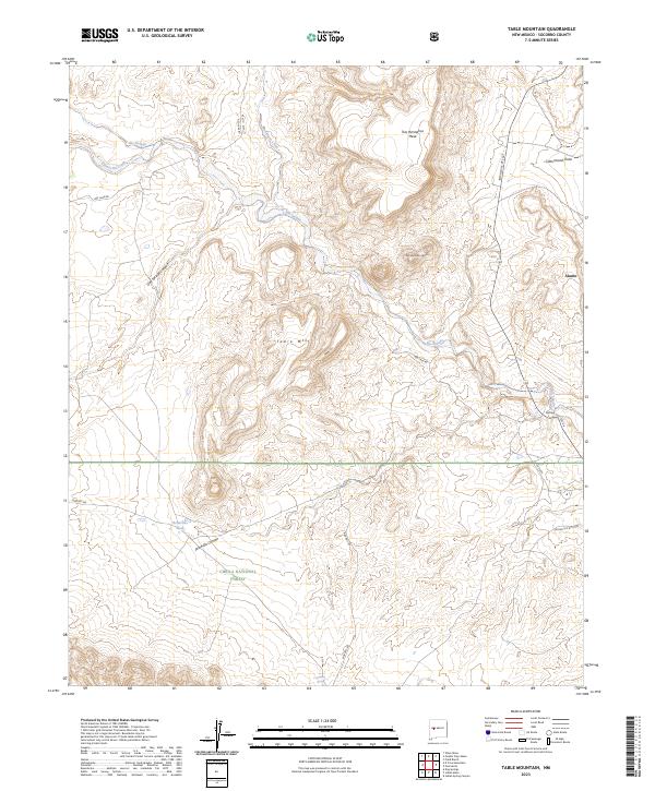
1964 Table Mountain
Socorro County, NM
1964 Tres Montosas
Socorro County, NM
1964 Vicks Peak
Socorro County, NM
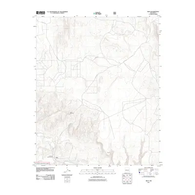
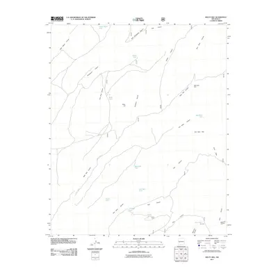
1964 Welty Hill
Socorro County, NM
1964 Wiley Mesa
Socorro County, NM
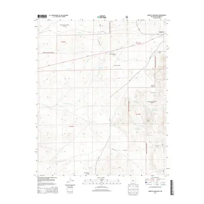
1965 Augustine Well
Socorro County, NM
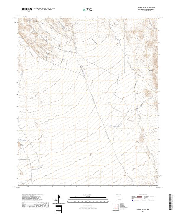
1965 Cienega Ranch
Socorro County, NM
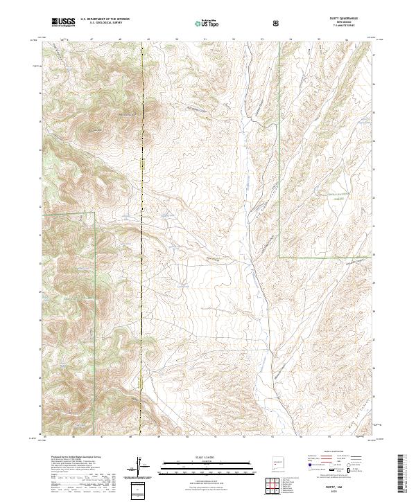
1965 Dusty
Socorro County, NM
1965 Kellog Well
Socorro County, NM
1965 Lion Mountain
Socorro County, NM
1965 Molino Peak
Socorro County, NM
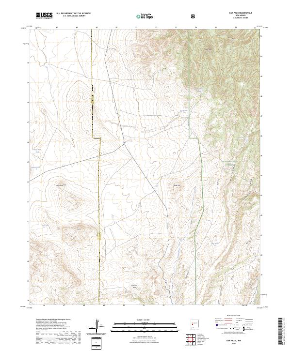
1965 Oak Peak
Socorro County, NM
1965 Puertecito Gap
Socorro County, NM
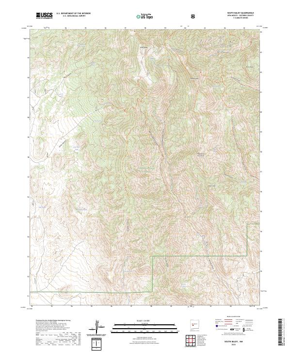
1965 South Baldy
Socorro County, NM
1965 Squaw Peak
Socorro County, NM
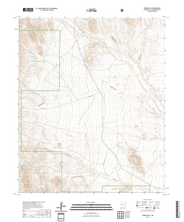
1965 Tenmile Hill
Socorro County, NM
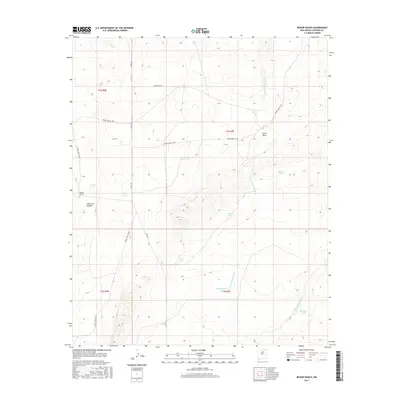
1972 Bishop Ranch
Socorro County, NM
1972 Bustos Well
Socorro County, NM
1972 Cat Mesa
Socorro County, NM
1972 Chupadera Spring
Socorro County, NM
1972 Orndorff Ranch
Socorro County, NM
1972 Rayo Hills
Socorro County, NM
1972 Scholle
Socorro County, NM
1972 Sierra De La Cruz
Socorro County, NM
1972 Sierra Larga North
Socorro County, NM
1972 Sierra Larga South
Socorro County, NM
1972 Turkey Ridge NE
Socorro County, NM
1972 Turkey Ridge
Socorro County, NM
1972 Turkey Ridge SW
Socorro County, NM
1972 Wilson Ranch
Socorro County, NM
1979 San Mateo Mountains
Socorro County, NM
1981 Black Hill
Socorro County, NM
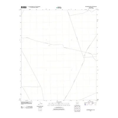
1981 Blakemore Well
Socorro County, NM
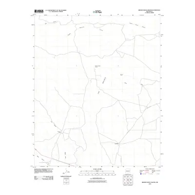
1981 Broken Back Crater
Socorro County, NM
1981 Canon Agua Buena
Socorro County, NM
1981 Claunch
Socorro County, NM
1981 Cooper Canyon
Socorro County, NM
1981 Dulce Draw
Socorro County, NM
1981 Foster Well
Socorro County, NM
1981 Granjean Well
Socorro County, NM
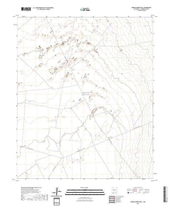
1981 Greens Baber Well
Socorro County, NM
1981 Harriet Ranch
Socorro County, NM
1981 Indian Well Wilderness
Socorro County, NM
1981 Polecat Draw
Socorro County, NM
1981 Pope
Socorro County, NM
1981 Trinity Site
Socorro County, NM
1981 Wrye Peak NW
Socorro County, NM
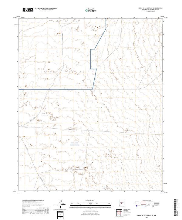
1982 Cerro De La Campana SE
Socorro County, NM
1982 Cerro De La Campana
Socorro County, NM
1982 Garden Spring Canyon
Socorro County, NM
1982 Little San Pascual Mountain
Socorro County, NM
1982 Lovelace Mesa
Socorro County, NM
1982 Mockingbird Gap
Socorro County, NM
1982 Oscura Mountains
Socorro County, NM
1982 Oscura Peak
Socorro County, NM
1982 Pink Peak
Socorro County, NM
1982 Prairie Spring
Socorro County, NM
1982 Red Canyon
Socorro County, NM
1982 San Antonio SE
Socorro County, NM
1982 San Marcial
Socorro County, NM
1982 Wrye Peak
Socorro County, NM
1982 Wrye Peak SW
Socorro County, NM
1985 Carbon Springs
Socorro County, NM
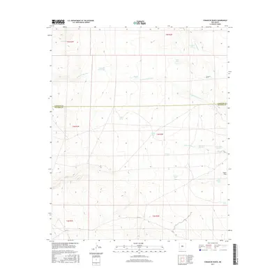
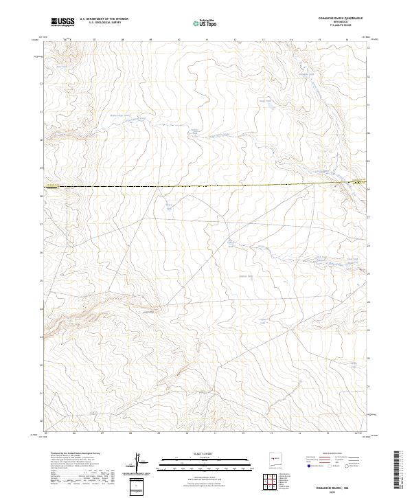
1985 Comanche Ranch
Socorro County, NM
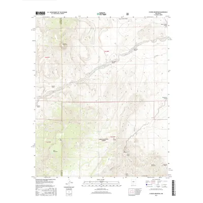
1985 Granite Mountain
Socorro County, NM
1985 Ladron Peak
Socorro County, NM
1985 Mesa Sarca
Socorro County, NM
1985 Riley
Socorro County, NM
1985 San Lorenzo Spring
Socorro County, NM
1985 Silver Creek
Socorro County, NM
1985 Water Canyon
Socorro County, NM
1989 Mesa Cencerro
Socorro County, NM
1991 Belen SW
Socorro County, NM
1995 Arrowhead Well
Socorro County, NM
1995 Arroyo Landavaso
Socorro County, NM
1995 Bay Buck Peaks
Socorro County, NM
1995 Blue Mountain
Socorro County, NM
1995 Carbon Springs
Socorro County, NM
1995 D Cross Mountain
Socorro County, NM
1995 Dog Springs
Socorro County, NM
1995 Dusty
Socorro County, NM
1995 Gallinas Peak
Socorro County, NM
1995 Granite Mountain
Socorro County, NM
1995 Grassy Lookout
Socorro County, NM
1995 Indian Mesa
Socorro County, NM
1995 Indian Spring Canyon
Socorro County, NM
1995 Kellog Well
Socorro County, NM
1995 La Jara Peak
Socorro County, NM
1995 Lion Mountain NW
Socorro County, NM
1995 Lion Mountain
Socorro County, NM
1995 Mesa Cencerro
Socorro County, NM
1995 Molino Peak
Socorro County, NM
1995 Monica Saddle
Socorro County, NM
1995 Montoya Butte
Socorro County, NM
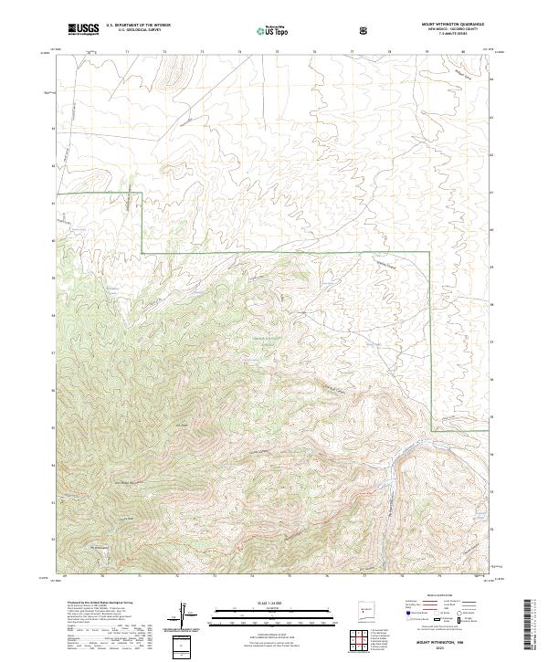
1995 Mount Withington
Socorro County, NM
1995 Oak Peak
Socorro County, NM
1995 Puertecito
Socorro County, NM
1995 Riley
Socorro County, NM
1995 San Juan Peak
Socorro County, NM
1995 Scholle
Socorro County, NM
1995 Silver Hill
Socorro County, NM
1995 South Baldy
Socorro County, NM
1995 Squaw Peak
Socorro County, NM
1995 Steel Hill
Socorro County, NM
1995 Table Mountain
Socorro County, NM
1995 Tenmile Hill
Socorro County, NM
1995 Tres Montosas
Socorro County, NM
1995 Vicks Peak
Socorro County, NM

1995 Water Canyon
Socorro County, NM
1995 Welty Hill
Socorro County, NM
1999 Wahoo Ranch
Socorro County, NM
2005 Dusty
Socorro County, NM
2010 Augustine Well
Socorro County, NM
2010 Becker
Socorro County, NM
2010 Becker SW
Socorro County, NM
2010 Belen SW
Socorro County, NM
2010 Bishop Ranch
Socorro County, NM
2010 Black Butte
Socorro County, NM
2010 Black Hill
Socorro County, NM
2010 Blakemore Well
Socorro County, NM
2010 Broken Back Crater
Socorro County, NM
2010 Bustos Well
Socorro County, NM
2010 Canon Agua Buena
Socorro County, NM
2010 Cat Mesa
Socorro County, NM
2010 Cerro De La Campana SE
Socorro County, NM
2010 Cerro De La Campana
Socorro County, NM
2010 Cerro Montoso
Socorro County, NM
2010 Chupadera Spring
Socorro County, NM
2010 Cienega Ranch
Socorro County, NM
2010 Claunch
Socorro County, NM
2010 Comanche Ranch
Socorro County, NM
2010 Cooper Canyon
Socorro County, NM
2010 Dulce Draw
Socorro County, NM
2010 Field Ranch
Socorro County, NM
2010 Fort Craig
Socorro County, NM
2010 Foster Well
Socorro County, NM
2010 Garden Spring Canyon
Socorro County, NM
2010 Granjean Well
Socorro County, NM
2010 Greens Baber Well
Socorro County, NM
2010 Harriet Ranch
Socorro County, NM
2010 Hickman Ranch
Socorro County, NM
2010 Indian Well Wilderness
Socorro County, NM
2010 Ladron Peak
Socorro County, NM
2010 La Joya NW
Socorro County, NM
2010 Little San Pascual Mountain
Socorro County, NM
2010 Loma De Las Canas
Socorro County, NM
2010 Lovelace Mesa
Socorro County, NM
2010 Mesa Del Yeso
Socorro County, NM
2010 Mesa Sarca
Socorro County, NM
2010 Mockingbird Gap
Socorro County, NM
2010 Orndorff Ranch
Socorro County, NM
2010 Oscura Peak
Socorro County, NM
2010 Paraje Well
Socorro County, NM
2010 Pink Peak
Socorro County, NM
2010 Polecat Draw
Socorro County, NM
2010 Pope
Socorro County, NM
2010 Prairie Spring
Socorro County, NM
2010 Pueblo Viejo Mesa
Socorro County, NM
2010 Puertecito Gap
Socorro County, NM
2010 Puerto De Los Cavadores
Socorro County, NM
2010 Rayo Hills
Socorro County, NM
2010 Red Canyon
Socorro County, NM
2010 San Antonio SE
Socorro County, NM
2010 San Lorenzo Spring
Socorro County, NM
2010 San Marcial
Socorro County, NM
2010 Sierra De La Cruz
Socorro County, NM
2010 Sierra Larga North
Socorro County, NM
2010 Sierra Larga South
Socorro County, NM
2010 Silver Creek
Socorro County, NM
2010 Trinity Site
Socorro County, NM
2010 Turkey Ridge NE
Socorro County, NM
2010 Turkey Ridge
Socorro County, NM
2010 Turkey Ridge SW
Socorro County, NM
2010 Wiley Mesa
Socorro County, NM
2010 Wilson Ranch
Socorro County, NM
2010 Wrye Peak NW
Socorro County, NM
2010 Wrye Peak
Socorro County, NM
2010 Wrye Peak SW
Socorro County, NM
2011 Alameda Spring
Socorro County, NM
2011 Arrowhead Well
Socorro County, NM
2011 Arroyo Landavaso
Socorro County, NM
2011 Bay Buck Peaks
Socorro County, NM
2011 Blue Mountain
Socorro County, NM
2011 Carbon Springs
Socorro County, NM
2011 D Cross Mountain
Socorro County, NM
2011 Dog Springs
Socorro County, NM
2011 Dusty
Socorro County, NM
2011 Gallinas Peak
Socorro County, NM
2011 Granite Mountain
Socorro County, NM
2011 Grassy Lookout
Socorro County, NM
2011 Indian Mesa
Socorro County, NM
2011 Indian Spring Canyon
Socorro County, NM
2011 Kellog Well
Socorro County, NM
2011 La Jara Peak
Socorro County, NM
2011 Lion Mountain NW
Socorro County, NM
2011 Lion Mountain
Socorro County, NM
2011 Mesa Cencerro
Socorro County, NM
2011 Molino Peak
Socorro County, NM
2011 Monica Saddle
Socorro County, NM
2011 Montoya Butte
Socorro County, NM
2011 Mount Withington
Socorro County, NM
2011 Oak Peak
Socorro County, NM
2011 Puertecito
Socorro County, NM
2011 Riley
Socorro County, NM
2011 San Juan Peak
Socorro County, NM
2011 Scholle
Socorro County, NM
2011 Silver Hill
Socorro County, NM
2011 South Baldy
Socorro County, NM
2011 Steel Hill
Socorro County, NM
2011 Table Mountain
Socorro County, NM
2011 Tenmile Hill
Socorro County, NM
2011 Tres Montosas
Socorro County, NM
2011 Vicks Peak
Socorro County, NM
2011 Wahoo Ranch
Socorro County, NM
2011 Water Canyon
Socorro County, NM
2011 Welty Hill
Socorro County, NM
2013 Alameda Spring
Socorro County, NM
2013 Arrowhead Well
Socorro County, NM
2013 Arroyo Landavaso
Socorro County, NM
2013 Augustine Well
Socorro County, NM
2013 Bay Buck Peaks
Socorro County, NM
2013 Becker
Socorro County, NM
2013 Becker SW
Socorro County, NM
2013 Belen SW
Socorro County, NM
2013 Bishop Ranch
Socorro County, NM
2013 Black Butte
Socorro County, NM
2013 Black Hill
Socorro County, NM
2013 Blakemore Well
Socorro County, NM
2013 Blue Mountain
Socorro County, NM
2013 Broken Back Crater
Socorro County, NM
2013 Bustos Well
Socorro County, NM
2013 Canon Agua Buena
Socorro County, NM
2013 Carbon Springs
Socorro County, NM
2013 Cat Mesa
Socorro County, NM
2013 Cerro De La Campana SE
Socorro County, NM
2013 Cerro De La Campana
Socorro County, NM
2013 Cerro Montoso
Socorro County, NM
2013 Chupadera Spring
Socorro County, NM
2013 Cienega Ranch
Socorro County, NM
2013 Claunch
Socorro County, NM
2013 Comanche Ranch
Socorro County, NM
2013 Cooper Canyon
Socorro County, NM
2013 D Cross Mountain
Socorro County, NM
2013 Dog Springs
Socorro County, NM
2013 Dulce Draw
Socorro County, NM
2013 Dusty
Socorro County, NM
2013 Field Ranch
Socorro County, NM
2013 Fort Craig
Socorro County, NM
2013 Foster Well
Socorro County, NM
2013 Gallinas Peak
Socorro County, NM
2013 Garden Spring Canyon
Socorro County, NM
2013 Granite Mountain
Socorro County, NM
2013 Granjean Well
Socorro County, NM
2013 Grassy Lookout
Socorro County, NM
2013 Greens Baber Well
Socorro County, NM
2013 Harriet Ranch
Socorro County, NM
2013 Hickman Ranch
Socorro County, NM
2013 Indian Mesa
Socorro County, NM
2013 Indian Spring Canyon
Socorro County, NM
2013 Indian Well Wilderness
Socorro County, NM
2013 Kellog Well
Socorro County, NM
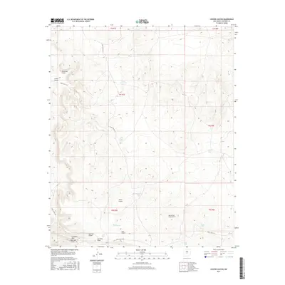
2013 Ladron Peak
Socorro County, NM
2013 La Jara Peak
Socorro County, NM
2013 La Joya NW
Socorro County, NM
2013 Lion Mountain NW
Socorro County, NM
2013 Lion Mountain
Socorro County, NM
2013 Little San Pascual Mountain
Socorro County, NM
2013 Loma De Las Canas
Socorro County, NM
2013 Lovelace Mesa
Socorro County, NM
2013 Mesa Cencerro
Socorro County, NM
2013 Mesa Del Yeso
Socorro County, NM
2013 Mesa Sarca
Socorro County, NM
2013 Mockingbird Gap
Socorro County, NM
2013 Molino Peak
Socorro County, NM
2013 Monica Saddle
Socorro County, NM
2013 Montoya Butte
Socorro County, NM
2013 Mount Withington
Socorro County, NM
2013 Oak Peak
Socorro County, NM
2013 Orndorff Ranch
Socorro County, NM
2013 Oscura Peak
Socorro County, NM
2013 Paraje Well
Socorro County, NM
2013 Pink Peak
Socorro County, NM
2013 Polecat Draw
Socorro County, NM
2013 Pope
Socorro County, NM
2013 Prairie Spring
Socorro County, NM
2013 Pueblo Viejo Mesa
Socorro County, NM
2013 Puertecito Gap
Socorro County, NM
2013 Puertecito
Socorro County, NM
2013 Puerto De Los Cavadores
Socorro County, NM
2013 Rayo Hills
Socorro County, NM
2013 Red Canyon
Socorro County, NM
2013 Riley
Socorro County, NM
2013 San Antonio SE
Socorro County, NM
2013 San Juan Peak
Socorro County, NM
2013 San Lorenzo Spring
Socorro County, NM
2013 San Marcial
Socorro County, NM
2013 Scholle
Socorro County, NM
2013 Sierra De La Cruz
Socorro County, NM
2013 Sierra Larga North
Socorro County, NM
2013 Sierra Larga South
Socorro County, NM
2013 Silver Creek
Socorro County, NM
2013 Silver Hill
Socorro County, NM
2013 South Baldy
Socorro County, NM
2013 Steel Hill
Socorro County, NM
2013 Table Mountain
Socorro County, NM
2013 Tenmile Hill
Socorro County, NM
2013 Tres Montosas
Socorro County, NM
2013 Trinity Site
Socorro County, NM
2013 Turkey Ridge NE
Socorro County, NM
2013 Turkey Ridge
Socorro County, NM
2013 Turkey Ridge SW
Socorro County, NM
2013 Vicks Peak
Socorro County, NM
2013 Wahoo Ranch
Socorro County, NM
2013 Water Canyon
Socorro County, NM
2013 Welty Hill
Socorro County, NM
2013 Wiley Mesa
Socorro County, NM
2013 Wilson Ranch
Socorro County, NM
2013 Wrye Peak NW
Socorro County, NM
2013 Wrye Peak
Socorro County, NM
2013 Wrye Peak SW
Socorro County, NM

2017 Alameda Spring
Socorro County, NM
2017 Arrowhead Well
Socorro County, NM
2017 Arroyo Landavaso
Socorro County, NM
2017 Augustine Well
Socorro County, NM
2017 Bay Buck Peaks
Socorro County, NM
2017 Becker
Socorro County, NM
2017 Becker SW
Socorro County, NM
2017 Belen SW
Socorro County, NM
2017 Bishop Ranch
Socorro County, NM
2017 Black Butte
Socorro County, NM
2017 Black Hill
Socorro County, NM
2017 Blakemore Well
Socorro County, NM
2017 Blue Mountain
Socorro County, NM
2017 Broken Back Crater
Socorro County, NM
2017 Bustos Well
Socorro County, NM
2017 Canon Agua Buena
Socorro County, NM
2017 Carbon Springs
Socorro County, NM
2017 Cat Mesa
Socorro County, NM
2017 Cerro De La Campana SE
Socorro County, NM
2017 Cerro De La Campana
Socorro County, NM
2017 Cerro Montoso
Socorro County, NM
2017 Chupadera Spring
Socorro County, NM
2017 Cienega Ranch
Socorro County, NM
2017 Claunch
Socorro County, NM
2017 Comanche Ranch
Socorro County, NM
2017 Cooper Canyon
Socorro County, NM
2017 D Cross Mountain
Socorro County, NM
2017 Dog Springs
Socorro County, NM
2017 Dulce Draw
Socorro County, NM
2017 Dusty
Socorro County, NM
2017 Field Ranch
Socorro County, NM
2017 Fort Craig
Socorro County, NM
2017 Foster Well
Socorro County, NM
2017 Gallinas Peak
Socorro County, NM
2017 Garden Spring Canyon
Socorro County, NM
2017 Granite Mountain
Socorro County, NM
2017 Granjean Well
Socorro County, NM
2017 Grassy Lookout
Socorro County, NM
2017 Greens Baber Well
Socorro County, NM
2017 Harriet Ranch
Socorro County, NM
2017 Hickman Ranch
Socorro County, NM
2017 Indian Mesa
Socorro County, NM
2017 Indian Spring Canyon
Socorro County, NM
2017 Indian Well Wilderness
Socorro County, NM
2017 Kellog Well
Socorro County, NM
2017 Ladron Peak
Socorro County, NM
2017 La Jara Peak
Socorro County, NM
2017 La Joya NW
Socorro County, NM
2017 Lion Mountain NW
Socorro County, NM
2017 Lion Mountain
Socorro County, NM
2017 Little San Pascual Mountain
Socorro County, NM
2017 Loma De Las Canas
Socorro County, NM
2017 Lovelace Mesa
Socorro County, NM
2017 Mesa Cencerro
Socorro County, NM
2017 Mesa Del Yeso
Socorro County, NM
2017 Mesa Sarca
Socorro County, NM
2017 Mockingbird Gap
Socorro County, NM
2017 Molino Peak
Socorro County, NM
2017 Monica Saddle
Socorro County, NM
2017 Montoya Butte
Socorro County, NM
2017 Mount Withington
Socorro County, NM
2017 Oak Peak
Socorro County, NM
2017 Orndorff Ranch
Socorro County, NM
2017 Oscura Peak
Socorro County, NM
2017 Paraje Well
Socorro County, NM
2017 Pink Peak
Socorro County, NM
2017 Polecat Draw
Socorro County, NM
2017 Pope
Socorro County, NM
2017 Prairie Spring
Socorro County, NM
2017 Pueblo Viejo Mesa
Socorro County, NM
2017 Puertecito Gap
Socorro County, NM
2017 Puertecito
Socorro County, NM
2017 Puerto De Los Cavadores
Socorro County, NM
2017 Rayo Hills
Socorro County, NM
2017 Red Canyon
Socorro County, NM
2017 Riley
Socorro County, NM
2017 San Antonio SE
Socorro County, NM
2017 San Juan Peak
Socorro County, NM
2017 San Lorenzo Spring
Socorro County, NM
2017 San Marcial
Socorro County, NM
2017 Scholle
Socorro County, NM
2017 Sierra De La Cruz
Socorro County, NM
2017 Sierra Larga North
Socorro County, NM
2017 Sierra Larga South
Socorro County, NM
2017 Silver Creek
Socorro County, NM
2017 Silver Hill
Socorro County, NM
2017 South Baldy
Socorro County, NM
2017 Steel Hill
Socorro County, NM
2017 Table Mountain
Socorro County, NM
2017 Tenmile Hill
Socorro County, NM
2017 Tres Montosas
Socorro County, NM
2017 Trinity Site
Socorro County, NM
2017 Turkey Ridge NE
Socorro County, NM
2017 Turkey Ridge
Socorro County, NM
2017 Turkey Ridge SW
Socorro County, NM
2017 Vicks Peak
Socorro County, NM
2017 Wahoo Ranch
Socorro County, NM
2017 Water Canyon
Socorro County, NM
2017 Welty Hill
Socorro County, NM
2017 Wiley Mesa
Socorro County, NM
2017 Wilson Ranch
Socorro County, NM
2017 Wrye Peak NW
Socorro County, NM
2017 Wrye Peak
Socorro County, NM
2017 Wrye Peak SW
Socorro County, NM
2020 Alameda Spring
Socorro County, NM
2020 Arrowhead Well
Socorro County, NM
2020 Arroyo Landavaso
Socorro County, NM
2020 Augustine Well
Socorro County, NM
2020 Bay Buck Peaks
Socorro County, NM
2020 Becker
Socorro County, NM
2020 Becker SW
Socorro County, NM
2020 Belen SW
Socorro County, NM
2020 Bishop Ranch
Socorro County, NM
2020 Black Butte
Socorro County, NM
2020 Black Hill
Socorro County, NM
2020 Blakemore Well
Socorro County, NM
2020 Blue Mountain
Socorro County, NM
2020 Broken Back Crater
Socorro County, NM
2020 Bustos Well
Socorro County, NM
2020 Canon Agua Buena
Socorro County, NM
2020 Carbon Springs
Socorro County, NM
2020 Cat Mesa
Socorro County, NM
2020 Cerro De La Campana SE
Socorro County, NM
2020 Cerro De La Campana
Socorro County, NM
2020 Cerro Montoso
Socorro County, NM
2020 Chupadera Spring
Socorro County, NM
2020 Cienega Ranch
Socorro County, NM
2020 Claunch
Socorro County, NM
2020 Comanche Ranch
Socorro County, NM
2020 Cooper Canyon
Socorro County, NM
2020 D Cross Mountain
Socorro County, NM
2020 Dog Springs
Socorro County, NM
2020 Dulce Draw
Socorro County, NM
2020 Dusty
Socorro County, NM
2020 Field Ranch
Socorro County, NM
2020 Fort Craig
Socorro County, NM

2020 Foster Well
Socorro County, NM
2020 Gallinas Peak
Socorro County, NM
2020 Garden Spring Canyon
Socorro County, NM
2020 Granite Mountain
Socorro County, NM
2020 Granjean Well
Socorro County, NM
2020 Grassy Lookout
Socorro County, NM
2020 Greens Baber Well
Socorro County, NM
2020 Harriet Ranch
Socorro County, NM
2020 Hickman Ranch
Socorro County, NM
2020 Indian Mesa
Socorro County, NM
2020 Indian Spring Canyon
Socorro County, NM
2020 Indian Well Wilderness
Socorro County, NM
2020 Kellog Well
Socorro County, NM
2020 Ladron Peak
Socorro County, NM
2020 La Jara Peak
Socorro County, NM
2020 La Joya NW
Socorro County, NM
2020 Lion Mountain NW
Socorro County, NM
2020 Lion Mountain
Socorro County, NM
2020 Little San Pascual Mountain
Socorro County, NM
2020 Loma De Las Canas
Socorro County, NM
2020 Lovelace Mesa
Socorro County, NM
2020 Mesa Cencerro
Socorro County, NM
2020 Mesa Del Yeso
Socorro County, NM
2020 Mesa Sarca
Socorro County, NM
2020 Mockingbird Gap
Socorro County, NM
2020 Molino Peak
Socorro County, NM
2020 Monica Saddle
Socorro County, NM
2020 Montoya Butte
Socorro County, NM
2020 Mount Withington
Socorro County, NM
2020 Oak Peak
Socorro County, NM
2020 Orndorff Ranch
Socorro County, NM
2020 Oscura Peak
Socorro County, NM
2020 Paraje Well
Socorro County, NM
2020 Pink Peak
Socorro County, NM
2020 Polecat Draw
Socorro County, NM
2020 Pope
Socorro County, NM
2020 Prairie Spring
Socorro County, NM
2020 Pueblo Viejo Mesa
Socorro County, NM
2020 Puertecito Gap
Socorro County, NM
2020 Puertecito
Socorro County, NM
2020 Puerto De Los Cavadores
Socorro County, NM
2020 Rayo Hills
Socorro County, NM
2020 Red Canyon
Socorro County, NM
2020 Riley
Socorro County, NM
2020 San Antonio SE
Socorro County, NM
2020 San Juan Peak
Socorro County, NM
2020 San Lorenzo Spring
Socorro County, NM
2020 San Marcial
Socorro County, NM
2020 Scholle
Socorro County, NM
2020 Sierra De La Cruz
Socorro County, NM
2020 Sierra Larga North
Socorro County, NM

2020 Sierra Larga South
Socorro County, NM
2020 Silver Creek
Socorro County, NM
2020 Silver Hill
Socorro County, NM
2020 South Baldy
Socorro County, NM
2020 Steel Hill
Socorro County, NM
2020 Table Mountain
Socorro County, NM
2020 Tenmile Hill
Socorro County, NM
2020 Tres Montosas
Socorro County, NM
2020 Trinity Site
Socorro County, NM
2020 Turkey Ridge NE
Socorro County, NM
2020 Turkey Ridge
Socorro County, NM
2020 Turkey Ridge SW
Socorro County, NM
2020 Vicks Peak
Socorro County, NM
2020 Wahoo Ranch
Socorro County, NM
2020 Water Canyon
Socorro County, NM
2020 Welty Hill
Socorro County, NM
2020 Wiley Mesa
Socorro County, NM
2020 Wilson Ranch
Socorro County, NM
2020 Wrye Peak NW
Socorro County, NM
2020 Wrye Peak
Socorro County, NM
2020 Wrye Peak SW
Socorro County, NM
2023 Alameda Spring
Socorro County, NM
2023 Arrowhead Well
Socorro County, NM
2023 Arroyo Landavaso
Socorro County, NM
2023 Augustine Well
Socorro County, NM
2023 Bay Buck Peaks
Socorro County, NM
2023 Becker
Socorro County, NM
2023 Becker SW
Socorro County, NM
2023 Belen SW
Socorro County, NM
2023 Bishop Ranch
Socorro County, NM
2023 Black Butte
Socorro County, NM
2023 Black Hill
Socorro County, NM
2023 Blakemore Well
Socorro County, NM
2023 Blue Mountain
Socorro County, NM
2023 Broken Back Crater
Socorro County, NM
2023 Bustos Well
Socorro County, NM
2023 Canon Agua Buena
Socorro County, NM
2023 Carbon Springs
Socorro County, NM
2023 Cat Mesa
Socorro County, NM
2023 Cerro De La Campana SE
Socorro County, NM
2023 Cerro De La Campana
Socorro County, NM
2023 Cerro Montoso
Socorro County, NM
2023 Chupadera Spring
Socorro County, NM
2023 Cienega Ranch
Socorro County, NM
2023 Claunch
Socorro County, NM
2023 Comanche Ranch
Socorro County, NM
2023 Cooper Canyon
Socorro County, NM
2023 D Cross Mountain
Socorro County, NM
2023 Dog Springs
Socorro County, NM
2023 Dulce Draw
Socorro County, NM
2023 Dusty
Socorro County, NM
2023 Field Ranch
Socorro County, NM
2023 Fort Craig
Socorro County, NM
2023 Foster Well
Socorro County, NM
2023 Gallinas Peak
Socorro County, NM
2023 Garden Spring Canyon
Socorro County, NM
2023 Granite Mountain
Socorro County, NM
2023 Granjean Well
Socorro County, NM
2023 Grassy Lookout
Socorro County, NM
2023 Greens Baber Well
Socorro County, NM
2023 Harriet Ranch
Socorro County, NM
2023 Hickman Ranch
Socorro County, NM
2023 Indian Mesa
Socorro County, NM
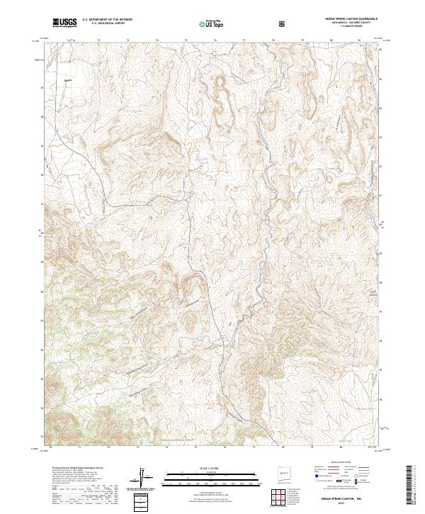
2023 Indian Spring Canyon
Socorro County, NM
2023 Indian Well Wilderness
Socorro County, NM
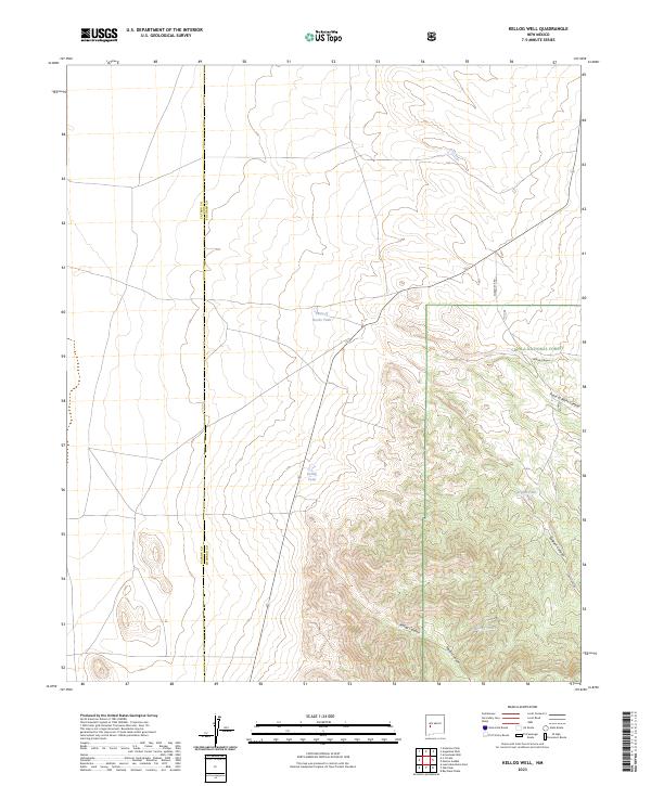
2023 Kellog Well
Socorro County, NM
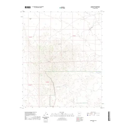
2023 Ladron Peak
Socorro County, NM
2023 La Jara Peak
Socorro County, NM
2023 La Joya NW
Socorro County, NM
2023 Lion Mountain NW
Socorro County, NM
2023 Lion Mountain
Socorro County, NM
2023 Little San Pascual Mountain
Socorro County, NM
2023 Loma De Las Canas
Socorro County, NM
2023 Lovelace Mesa
Socorro County, NM
2023 Mesa Cencerro
Socorro County, NM
2023 Mesa Del Yeso
Socorro County, NM
2023 Mesa Sarca
Socorro County, NM
2023 Mockingbird Gap
Socorro County, NM
2023 Molino Peak
Socorro County, NM
2023 Monica Saddle
Socorro County, NM
2023 Montoya Butte
Socorro County, NM
2023 Mount Withington
Socorro County, NM
2023 Oak Peak
Socorro County, NM
2023 Orndorff Ranch
Socorro County, NM
2023 Oscura Peak
Socorro County, NM
2023 Paraje Well
Socorro County, NM
2023 Pink Peak
Socorro County, NM
2023 Polecat Draw
Socorro County, NM
2023 Pope
Socorro County, NM
2023 Prairie Spring
Socorro County, NM
2023 Pueblo Viejo Mesa
Socorro County, NM
2023 Puertecito Gap
Socorro County, NM
2023 Puertecito
Socorro County, NM
2023 Puerto De Los Cavadores
Socorro County, NM
2023 Rayo Hills
Socorro County, NM
2023 Red Canyon
Socorro County, NM
2023 Riley
Socorro County, NM
2023 San Antonio SE
Socorro County, NM
2023 San Juan Peak
Socorro County, NM
2023 San Lorenzo Spring
Socorro County, NM
2023 San Marcial
Socorro County, NM
2023 Scholle
Socorro County, NM
2023 Sierra De La Cruz
Socorro County, NM
2023 Sierra Larga North
Socorro County, NM
2023 Sierra Larga South
Socorro County, NM
2023 Silver Creek
Socorro County, NM
2023 Silver Hill
Socorro County, NM
2023 South Baldy
Socorro County, NM
2023 Steel Hill
Socorro County, NM
2023 Table Mountain
Socorro County, NM
2023 Tenmile Hill
Socorro County, NM
2023 Tres Montosas
Socorro County, NM
2023 Trinity Site
Socorro County, NM
2023 Turkey Ridge NE
Socorro County, NM
2023 Turkey Ridge
Socorro County, NM
2023 Turkey Ridge SW
Socorro County, NM
2023 Vicks Peak
Socorro County, NM
2023 Wahoo Ranch
Socorro County, NM
2023 Water Canyon
Socorro County, NM
2023 Welty Hill
Socorro County, NM
2023 Wiley Mesa
Socorro County, NM
2023 Wilson Ranch
Socorro County, NM
2023 Wrye Peak NW
Socorro County, NM
2023 Wrye Peak
Socorro County, NM
2023 Wrye Peak SW
Socorro County, NM