
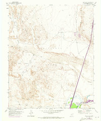
1952 Map of San Anacia
USGS Topo · Published 1953About this map
San Acacia sits at the vital confluence of the Rio Salado and the Rio Grande, serving as a focal point for water management and transit in Socorro County. The map details the intricate irrigation network of the Alamillo Ditch, San Acacia Canal, and a series of drainage canals that supported agricultural life along the riverbanks. To the west, the arid foothills of the Sierra Ladrones and the high ridges of Loma Blanca dominate the terrain, separated from the valley by expansive tracts like the Sevilleta Grant.
Find a feature on this map
26 named features on this map. Tap any name to fly to it.
Don’t see what you’re looking for? This feature index may not catch every label — zoom into the map to look around manually.
Map Details
Editions of this 1952 San Anacia Map
2 editions found
Other maps of this area

1906 · Socorro
USGS Topo · 1:62,500

1916 · La Joya
USGS Topo · 1:125,000

1952 · La Joya NW
USGS Topo · 1:24,000

1952 · La Joya
USGS Topo · 1:24,000

1952 · Abeytas
USGS Topo · 1:24,000

1954 · Socorro
USGS Topo · 1:250,000

1958 · Socorro
USGS Topo · 1:250,000

1959 · Mesa Del Yeso
USGS Topo · 1:24,000

1959 · Lemitar
USGS Topo · 1:24,000

1959 · Magdalena
USGS Topo · 1:62,500