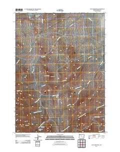
2011 Map of Ladycomb Peak
USGS Topo · Published 2011About this map
Ladycomb Peak and the adjacent Lady Comb landform anchor this high-desert landscape in southeastern Oregon, where a complex network of seasonal drainages feeds into the Catlow Valley. The terrain is defined by the convergence of several major creek systems, including Horse Creek, Willow Creek, and Little Cottonwood Creek, which flow through a sparsely settled region of the Great Basin. Ranching and remote outposts are the primary human markers, evidenced by McDade Ranch in the north and small structures like Stergen Cabin and McLean Cabin further south.
Find a feature on this map
19 named features on this map. Tap any name to fly to it.
Don’t see what you’re looking for? This feature index may not catch every label — zoom into the map to look around manually.
Map Details
Editions of this 2011 Ladycomb Peak Map
This is the sole edition of this map. No revisions or reprints were ever made.
Other maps of this area

1955 · Adel
USGS Topo · 1:250,000

1957 · Adel
USGS Topo · 1:250,000

1958 · Adel
USGS Topo · 1:250,000

1962 · Adel
USGS Topo · 1:250,000

1971 · Fields Basin
USGS Topo · 1:24,000

1971 · Fields
USGS Topo · 1:24,000

1971 · Borax Lake
USGS Topo · 1:24,000
1981 · Colony Ranch
USGS Topo · 1:24,000
1981 · Van Horn Basin
USGS Topo · 1:24,000
1981 · Tumtum Lake
USGS Topo · 1:24,000