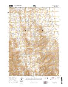
2017 Map of Ladycomb Peak
USGS Topo · Published 2017About this map
Ladycomb Peak stands as the central landmark of this High Desert landscape in Harney County, Oregon. The terrain is defined by the eastern edge of the Pueblo Mountains, where steep drainages like Rough Canyon and Williams Canyon transition into a complex network of seasonal creeks. The presence of Willow Creek Pockets and Cold Spring suggests the vital importance of water sources in this arid environment, providing critical points for livestock and wildlife. Transportation is limited to the north-south corridor of Fields Dr, which follows the base of the mountains. The map illustrates a classic Great Basin drainage pattern, with numerous watercourses such as Little Willow Cr, N Fork Willow Cr, and S Fork Willow Cr radiating from the high peaks toward the surrounding flats.
Find a feature on this map
26 named features on this map. Tap any name to fly to it.
Don’t see what you’re looking for? This feature index may not catch every label — zoom into the map to look around manually.
Map Details
Editions of this 2017 Ladycomb Peak Map
This is the sole edition of this map. No revisions or reprints were ever made.
Other maps of this area

1955 · Adel
USGS Topo · 1:250,000

1957 · Adel
USGS Topo · 1:250,000

1958 · Adel
USGS Topo · 1:250,000

1962 · Adel
USGS Topo · 1:250,000

1971 · Fields Basin
USGS Topo · 1:24,000

1971 · Fields
USGS Topo · 1:24,000

1971 · Borax Lake
USGS Topo · 1:24,000
1981 · Colony Ranch
USGS Topo · 1:24,000
1981 · Van Horn Basin
USGS Topo · 1:24,000
1981 · Tumtum Lake
USGS Topo · 1:24,000