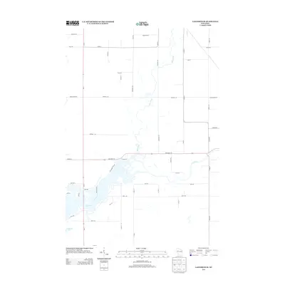
2013 Map of Ladysmith SE
USGS Topo · Published 2013About this map
The Jump River winds through this rural landscape in Rusk and Chippewa Counties, defining the hydrology and early travel corridors of the region. The confluence of Main Creek and the river creates a complex network of wetlands and small islands, accessible by Pine Island Rd and Whispering Pines Dr. The 2013 landscape shows a transition from agricultural grid roads to recreational shoreline developments, particularly near Roedecker Lake and along Shore Dr. Significant infrastructure like Wi-27 and State Road 194 serves as the primary skeleton for this area, which remains largely defined by its water bodies and named rural routes such as Skunk Cr and Meadows Rd. Local history is preserved in these specific road names, often reflecting the families and natural features of the Northwoods.
Find a feature on this map
45 named features on this map. Tap any name to fly to it.
Don’t see what you’re looking for? This feature index may not catch every label — zoom into the map to look around manually.
Map Details
Editions of this 2013 Ladysmith SE Map
This is the sole edition of this map. No revisions or reprints were ever made.
Other maps of this area

1947 · Sheldon
USGS Topo · 1:48,000

1948 · Ladysmith
USGS Topo · 1:48,000

1949 · Sheldon
USGS Topo · 1:48,000

1950 · Ladysmith
USGS Topo · 1:48,000

1951 · Cornell
USGS Topo · 1:62,500

1951 · Gilman
USGS Topo · 1:62,500

1953 · Rice Lake
USGS Topo · 1:250,000

1959 · Rice Lake
USGS Topo · 1:250,000
1971 · Ladysmith
USGS Topo · 1:24,000
1971 · Thornapple
USGS Topo · 1:24,000