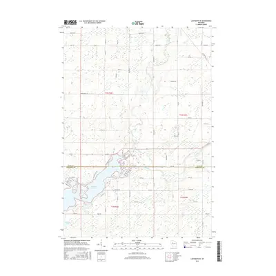
2015 Map of Ladysmith SE
USGS Topo · Published 2015About this map
Holcombe Flowage dominates the southwestern corner of this landscape, its irregular shoreline reaching up to meet the confluence of the Jump River and several smaller tributaries. This aquatic system defines the geography where the border between Rusk Co and Chippewa Co intersects the water. To the north and east, the terrain is structured by a grid of rural roads and drainage ways like Main Creek and Skunk Cr. The land use pattern is reflected in family and descriptive road names such as Felski Rd, Giebel Rd, and Railroad Ave, which point to a history of agriculture and timber management in this part of northern Wisconsin. Residential pockets appear along the water's edge at Paradise Point Rd and Whispering Pines Dr, showing the transition from working landscape to recreational waterfront near the Roedecker Lake area.
Find a feature on this map
41 named features on this map. Tap any name to fly to it.
Don’t see what you’re looking for? This feature index may not catch every label — zoom into the map to look around manually.
Map Details
Editions of this 2015 Ladysmith SE Map
This is the sole edition of this map. No revisions or reprints were ever made.
Other maps of this area

1947 · Sheldon
USGS Topo · 1:48,000

1948 · Ladysmith
USGS Topo · 1:48,000

1949 · Sheldon
USGS Topo · 1:48,000

1950 · Ladysmith
USGS Topo · 1:48,000

1951 · Cornell
USGS Topo · 1:62,500

1951 · Gilman
USGS Topo · 1:62,500

1953 · Rice Lake
USGS Topo · 1:250,000

1959 · Rice Lake
USGS Topo · 1:250,000
1971 · Ladysmith
USGS Topo · 1:24,000
1971 · Thornapple
USGS Topo · 1:24,000