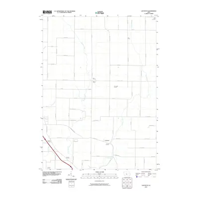
2010 Map of Lafayette
USGS Topo · Published 2010About this map
The branching headwaters of East Otter Creek and West Otter Creek define this rural landscape north of Marion, Iowa. The small settlements of Alice and Lafayette anchor the community, surrounded by a dense network of family-named cemeteries that provide a clear map for genealogical research. Historically significant burial grounds like Alice Cemetery, Ashlock Cemetery, Lafayette Cemetery, Oliphant Cemetery, and Squires Cemetery are scattered across the township, marking the long-standing family farmsteads of the region. Transportation in this agricultural corridor is organized around established routes like Lafayette Rd and Central City Rd, while the Reynolds Airport provides a modern aviation landmark amidst the traditional prairie land. This map documents a quiet period of rural stability in Linn County, where the transition from the old settlement of West Prairie to modern road improvements remains visible.
Find a feature on this map
53 named features on this map. Tap any name to fly to it.
Don’t see what you’re looking for? This feature index may not catch every label — zoom into the map to look around manually.
Map Details
Editions of this 2010 Lafayette Map
This is the sole edition of this map. No revisions or reprints were ever made.
Other maps of this area

1888 · Shellsburg
USGS Topo · 1:62,500

1888 · Marion
USGS Topo · 1:62,500

1889 · Marion
USGS Topo · 1:62,500

1889 · Shellsburg
USGS Topo · 1:62,500

1899 · Shellsburg
USGS Topo · 1:62,500

1903 · Winthrop
USGS Topo · 1:125,000

1959 · Dubuque
USGS Topo · 1:250,000

1961 · Dubuque
USGS Topo · 1:250,000

1962 · Dubuque
USGS Topo · 1:250,000
1967 · Cedar Rapids North
USGS Topo · 1:24,000