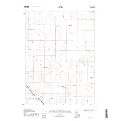
2018 Map of Lafayette
USGS Topo · Published 2018About this map
Lafayette and Alice serve as central points in this rural Linn County landscape, where the agricultural grid is deeply carved by the branching paths of W Otter Cr and E Otter Cr. The map reveals a high concentration of local burial grounds, providing significant data for genealogists tracing family histories through the West Prairie Cem, Alice Cem, and Ashlock Cem. Further south, the Lafayette Cem and Oliphant Cem sit near the crossroads of the growing community of Alburnett. The road network, including historic routes like Paris Rd and Troy Mills Rd, follows the section lines of the township boundaries, illustrating the enduring structure of Iowa's land management system. Tributaries such as Apple Cr and Nelson Cr weave through the terrain, defining the natural drainage patterns that have shaped local settlement for generations.
Find a feature on this map
69 named features on this map. Tap any name to fly to it.
Don’t see what you’re looking for? This feature index may not catch every label — zoom into the map to look around manually.
Map Details
Editions of this 2018 Lafayette Map
This is the sole edition of this map. No revisions or reprints were ever made.
Other maps of this area

1888 · Shellsburg
USGS Topo · 1:62,500

1888 · Marion
USGS Topo · 1:62,500

1889 · Marion
USGS Topo · 1:62,500

1889 · Shellsburg
USGS Topo · 1:62,500

1899 · Shellsburg
USGS Topo · 1:62,500

1903 · Winthrop
USGS Topo · 1:125,000

1959 · Dubuque
USGS Topo · 1:250,000

1961 · Dubuque
USGS Topo · 1:250,000

1962 · Dubuque
USGS Topo · 1:250,000
1967 · Cedar Rapids North
USGS Topo · 1:24,000