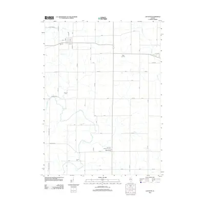
2012 Map of Lafayette
USGS Topo · Published 2012About this map
West Jersey stands as a focal point in this portion of Stark County, where the agricultural landscape is defined by the winding paths of Walnut Cr and Indian Cr. The map reveals a deeply rooted rural community, highlighted by family-connected landmarks such as the Morgan - Richey Jersey Farm and the West Jersey Methodist Churchyard. For those tracing local history, the distribution of burial sites including Lafayette Cem, McClenahan Cem, and Shockley Cem provides significant genealogical waypoints across the township. The infrastructure is characterized by a precise grid of county roads and highways, such as Co Hwy-7 and Co Hwy-16, which connect isolated farmsteads to the larger regional network. This survey captures the enduring character of the Illinois prairie, where the placement of small cemeteries and churchyards serves as a record of early settlement patterns and family lineages.
Find a feature on this map
32 named features on this map. Tap any name to fly to it.
Don’t see what you’re looking for? This feature index may not catch every label — zoom into the map to look around manually.
Map Details
Editions of this 2012 Lafayette Map
This is the sole edition of this map. No revisions or reprints were ever made.
Other maps of this area

1931 · Galva
USGS Topo · 1:48,000

1940 · Galva
USGS Topo · 1:62,500

1941 · Maquon
USGS Topo · 1:62,500

1943 · Maquon
USGS Topo · 1:62,500

1944 · Galva
USGS Topo · 1:62,500

1944 · Kewanee
USGS Topo · 1:62,500

1944 · Elmwood
USGS Topo · 1:62,500

1948 · Elmwood
USGS Topo · 1:62,500
1953 · Galva
USGS Topo · 1:24,000

1958 · Burlington
USGS Topo · 1:250,000