
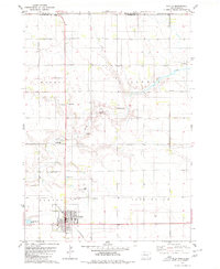
1979 Map of Laffey Lake
USGS Topo · Published 1980About this map
The rolling plains of Aurora County are defined here by a series of distinct township boundaries and drainage patterns as they appeared in the late 1970s. Laffey Lake sits in the eastern portion of the landscape, while the serpentine course of Platte Creek and its East Fork Platte Creek provide the primary water sources for this agricultural region. The map illustrates a rigid grid of property lines and field fences across the townships of Gales, Crystal Lake, Washington, and Center. These administrative divisions emphasize the systematic settlement of the Dakota territory. Small-scale resource extraction is evident through several scattered gravel pits, indicating the localized infrastructure needs of this rural community during the era.
Find a feature on this map
9 named features on this map. Tap any name to fly to it.
Don’t see what you’re looking for? This feature index may not catch every label — zoom into the map to look around manually.
Map Details
Editions of this 1979 Laffey Lake Map
This is the sole edition of this map. No revisions or reprints were ever made.
Other maps of this area

1955 · Mitchell
USGS Topo · 1:250,000

1959 · Mitchell
USGS Topo · 1:250,000

1979 · Cedar Grove Colony
USGS Topo · 1:24,000

1979 · New Holland
USGS Topo · 1:24,000

1979 · Crystal Lake
USGS Topo · 1:24,000

1979 · White Lake
USGS Topo · 1:24,000

1979 · Platte Lake
USGS Topo · 1:24,000

1979 · Aurora Center
USGS Topo · 1:24,000

1979 · Joubert
USGS Topo · 1:24,000
1979 · Platte
USGS Topo · 1:24,000
Featured Places
- Gales Township, SD
- Crystal Lake Township, SD
- Center Township, SD
- Washington Township, SD
- Aurora County, SD