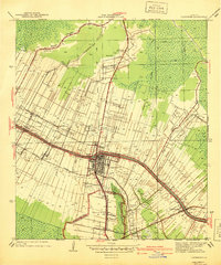
1940 Map of Lafourche
USGS Topo · Published 1940About this map
Bayou Lafourche serves as the central artery for this 1940 survey, which reveals a landscape defined by the deep-seated plantation economy and early industrial infrastructure of South Louisiana. The city of Thibodaux acts as the primary hub, where the Texas and Pacific and Southern Pacific railroads converge to move agricultural goods from the surrounding estates. Named holdings such as St James Plantation, Laurel Valley Plantation, and Greenwood Plantation dominate the land use, showing the distinctive long-lot field patterns extending back from the bayou. Significant local landmarks include Morningstar Ch and Choupique Sch, which served the rural communities of Roger and Brule. The presence of several Pump Sta locations and a Water Supply Pipe Line highlights the engineered water management required to maintain productivity near the edges of Devil Swamp.
Find a feature on this map
31 named features on this map. Tap any name to fly to it.
Don’t see what you’re looking for? This feature index may not catch every label — zoom into the map to look around manually.
Map Details
Editions of this 1940 Lafourche Map
This is the sole edition of this map. No revisions or reprints were ever made.
Other maps of this area

1892 · Lac Des Allemands
USGS Topo · 1:62,500

1892 · Gibson
USGS Topo · 1:62,500

1892 · Houma
USGS Topo · 1:62,500

1892 · Thibodaux
USGS Topo · 1:62,500

1897 · Gibson
USGS Topo · 1:62,500

1927 · Thibodaux NW
USGS Topo · 1:31,680

1932 · Lac Des Allemands NW
USGS Topo · 1:31,680

1932 · Lac Des Allemands SW
USGS Topo · 1:31,680

1932 · Thibodaux NE
USGS Topo · 1:31,680

1932 · Houma NW
USGS Topo · 1:31,680