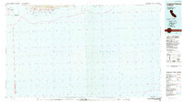
1984 Map of Laguna Harbor
USGS Topo · Published 1984About this map
Santa Cruz Island National Park and Santa Rosa Island dominate the northern portion of this 1984 coastal study, providing a detailed record of the islands within the Channel Islands National Park. The maritime geography is defined by a series of protected coves and landings, including Laguna Harbor, Malva Real Anchorage, and Alamos Anchorage. The presence of a Landing Field on Santa Cruz Island suggests the logistical requirements for park management and access during this era.
Find a feature on this map
22 named features on this map. Tap any name to fly to it.
Don’t see what you’re looking for? This feature index may not catch every label — zoom into the map to look around manually.
Map Details
Editions of this 1984 Laguna Harbor Map
This is the sole edition of this map. No revisions or reprints were ever made.
Other maps of this area

1900 · Triunfo Pass
USGS Topo · 1:62,500

1903 · Camulos
USGS Topo · 1:125,000

1904 · Hueneme
USGS Topo · 1:62,500

1921 · Triunfo Pass
USGS Topo · 1:62,500

1932 · Arroyo Sequit
USGS Topo · 1:24,000

1942 · Hueneme
USGS Topo · 1:62,500
1943 · Santa Rosa Island East
USGS Topo · 1:24,000

1943 · Hueneme
USGS Topo · 1:62,500
1943 · Triunfo Pass
USGS Topo · 1:62,500
1943 · Santa Cruz Island A
USGS Topo · 1:24,000