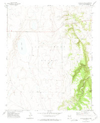
1971 Map of Laguna La Monia
USGS Topo · Published 1975About this map
The vast Las Vegas Grant dominates this 1970s landscape of San Miguel County, showing a transition from the level plains of the west to the deep breaks of the east. At the heart of this survey lies Laguna La Monia, a prominent water body that likely served as a vital focal point for the surrounding cattle operations. The presence of Feliz Ranch, Anchor Ranch, and Bryan Pens indicates an established ranching economy, where small settlements and corrals are scattered across the high country. As the elevation drops sharply toward the eastern edge, the terrain becomes defined by complex drainage systems such as Cañoncito del las Cuevas and Box Canyon. This study also captures more rugged features like the high point of Mogote, providing a look at the topographical variety that defined New Mexico's rangelands during the early 1970s.
Find a feature on this map
9 named features on this map. Tap any name to fly to it.
Don’t see what you’re looking for? This feature index may not catch every label — zoom into the map to look around manually.
Map Details
Editions of this 1971 Laguna La Monia Map
This is the sole edition of this map. No revisions or reprints were ever made.
Other maps of this area

1889 · Las Vegas
USGS Topo · 1:125,000

1890 · Bernal
USGS Topo · 1:125,000

1891 · Bernal
USGS Topo · 1:125,000

1891 · Las Vegas
USGS Topo · 1:125,000

1892 · Watrous
USGS Topo · 1:125,000

1892 · Corazon
USGS Topo · 1:125,000

1893 · Las Vegas
USGS Topo · 1:125,000

1894 · Corazon
USGS Topo · 1:125,000

1894 · Watrous
USGS Topo · 1:125,000

1894 · Bernal
USGS Topo · 1:125,000