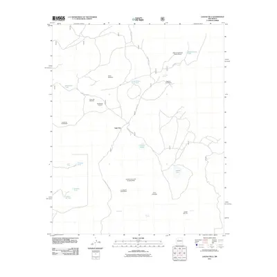
2011 Map of Laguna Seca
USGS Topo · Published 2011About this map
Eagle Nest and La Jolla de Santa Rosa anchor this high-altitude landscape in McKinley County, where the terrain is defined by a series of volcanic and mesa formations. The network of natural water sources and man-made infrastructure is critical here, with features like Ojo Eugenio, Guadalupe Spring, and Laguna del Vino supporting the local ecosystem. Significant landforms like Cerro Montoso and the Cerros de Guadalupe rise above the surrounding flats, while the Valle de las Animas suggests the historical naming of these corridors. This 2011 survey by the U.S. Geological Survey details the vital importance of springs and stock tanks, such as Horse Pasture Stock Tank, in a region where water management is central to the land's utility. The presence of Forest SVC RD 550 and Forest Service RD 194 reveals the accessibility of the high country via the Forest Service road network.
Find a feature on this map
28 named features on this map. Tap any name to fly to it.
Don’t see what you’re looking for? This feature index may not catch every label — zoom into the map to look around manually.
Map Details
Editions of this 2011 Laguna Seca Map
This is the sole edition of this map. No revisions or reprints were ever made.
Other maps of this area

1883 · Mt. Taylor
USGS Topo · 1:250,000

1886 · Mt. Taylor
USGS Topo · 1:250,000

1892 · Mt. Taylor
USGS Topo · 1:250,000

1899 · Mt. Taylor
USGS Topo · 1:250,000

1958 · Albuquerque
USGS Topo · 1:250,000

1961 · Marquez
USGS Topo · 1:24,000

1961 · Cerro Parido
USGS Topo · 1:24,000

1961 · Cerro Tinaja
USGS Topo · 1:24,000

1961 · El Dado Mesa
USGS Topo · 1:24,000
1961 · La Gotera
USGS Topo · 1:24,000