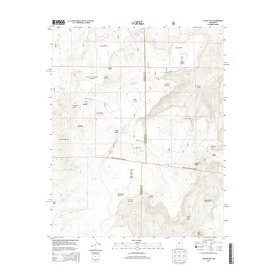
2013 Map of Laguna Seca
USGS Topo · Published 2013About this map
Cibola National Forest encompasses the high-desert terrain of this McKinley and Sandoval County borderland, where the settlement of Eagle Nest sits amidst a network of canyons and mesas. The landscape is defined by the drainage of Cañon de Santa Rosa and Guadalupe Canyon, with significant elevations marked by Santa Rosa Peaks and the prominent Black Mesa.
Find a feature on this map
46 named features on this map. Tap any name to fly to it.
Don’t see what you’re looking for? This feature index may not catch every label — zoom into the map to look around manually.
Map Details
Editions of this 2013 Laguna Seca Map
This is the sole edition of this map. No revisions or reprints were ever made.
Other maps of this area

1883 · Mt. Taylor
USGS Topo · 1:250,000

1886 · Mt. Taylor
USGS Topo · 1:250,000

1892 · Mt. Taylor
USGS Topo · 1:250,000

1899 · Mt. Taylor
USGS Topo · 1:250,000

1958 · Albuquerque
USGS Topo · 1:250,000

1961 · Marquez
USGS Topo · 1:24,000

1961 · Cerro Parido
USGS Topo · 1:24,000

1961 · Cerro Tinaja
USGS Topo · 1:24,000

1961 · El Dado Mesa
USGS Topo · 1:24,000
1961 · La Gotera
USGS Topo · 1:24,000