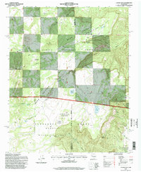
1995 Map of Laguna Seca
USGS Topo · Published 1998About this map
Nuestra Señora de la Luz de las Lagunitas Grant defines the southeastern corner of this high-altitude landscape, where historical land grants meet modern wildlife management. The boundary between McKinley and Sandoval counties bisects the region, crossing the Chivato Mesa and the drainage of Tapia Canyon. Water sources, critical for ranching and wildlife in this arid environment, are meticulously documented through a network of tanks and natural springs such as Guadalupe Spring, Ojo Eugenio, and Ojo Frio.
Find a feature on this map
39 named features on this map. Tap any name to fly to it.
Don’t see what you’re looking for? This feature index may not catch every label — zoom into the map to look around manually.
Map Details
Editions of this 1995 Laguna Seca Map
This is the sole edition of this map. No revisions or reprints were ever made.
Other maps of this area

1883 · Mt. Taylor
USGS Topo · 1:250,000

1886 · Mt. Taylor
USGS Topo · 1:250,000

1892 · Mt. Taylor
USGS Topo · 1:250,000

1899 · Mt. Taylor
USGS Topo · 1:250,000

1958 · Albuquerque
USGS Topo · 1:250,000

1961 · Marquez
USGS Topo · 1:24,000

1961 · Cerro Parido
USGS Topo · 1:24,000

1961 · Cerro Tinaja
USGS Topo · 1:24,000

1961 · El Dado Mesa
USGS Topo · 1:24,000
1961 · La Gotera
USGS Topo · 1:24,000