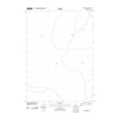
2010 Map of Laidlaw Butte
USGS Topo · Published 2010About this map
Laidlaw Butte stands as a prominent terrain feature in this high desert landscape of Idaho's Snake River Plain. This 2010 survey illustrates a region where water management is critical, evidenced by several small-scale impoundments and natural basins scattered across the dry terrain. The presence of Carpenter Reservoir and Baird Reservoir indicates the localized efforts to capture runoff in a territory defined by sparse water sources. To the northeast, Hillside Lake and Sage Lake occupy depressions in the volcanic landscape, while Brigham Lake Reservoir marks a developed water point to the southeast. The map reveals the intricate network of unimproved roads and 4WD tracks that provide the only access through this desolate portion of Blaine County.
Find a feature on this map
6 named features on this map. Tap any name to fly to it.
Don’t see what you’re looking for? This feature index may not catch every label — zoom into the map to look around manually.
Map Details
Editions of this 2010 Laidlaw Butte Map
This is the sole edition of this map. No revisions or reprints were ever made.
Other maps of this area

1955 · Idaho Falls
USGS Topo · 1:250,000

1958 · Idaho Falls
USGS Topo · 1:250,000

1972 · North Laidlaw Butte
USGS Topo · 1:24,000

1972 · Little Park
USGS Topo · 1:24,000

1972 · Laidlaw Lake
USGS Topo · 1:24,000

1972 · Bear Den Butte
USGS Topo · 1:24,000

1972 · Laidlaw Butte
USGS Topo · 1:24,000

1972 · Bottleneck Lake
USGS Topo · 1:24,000

1978 · Craters Of The Moon
USGS Topo · 1:100,000
1979 · Paddelford Flat
USGS Topo · 1:24,000