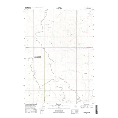
2017 Map of Laidlaw Butte
USGS Topo · Published 2017About this map
Craters of the Moon National Monument defines the western portion of this high-desert landscape, where volcanic geology meets the administrative borders of Blaine, Lincoln, and Minidoka counties. The area is characterized by isolated water features and catchments, such as Carraway Reservoir and Baird Reservoir, which support life in this arid environment. Laidlaw Butte stands as a prominent topographical landmark, rising above a network of smaller lakes including Sage Lake, Hillside Lake, and Baldwin Lake. This 2017 survey by the U.S. Geological Survey illustrates a landscape primarily shaped by modern land management and natural conservation, where the lack of formal settlements highlights the area's role as a protected wilderness and ranching resource. Researchers can trace the distribution of ephemeral water sources like Little Deer Lakes and Crossing Lake across the sagebrush steppe.
Find a feature on this map
18 named features on this map. Tap any name to fly to it.
Don’t see what you’re looking for? This feature index may not catch every label — zoom into the map to look around manually.
Map Details
Editions of this 2017 Laidlaw Butte Map
This is the sole edition of this map. No revisions or reprints were ever made.
Other maps of this area

1955 · Idaho Falls
USGS Topo · 1:250,000

1958 · Idaho Falls
USGS Topo · 1:250,000

1972 · North Laidlaw Butte
USGS Topo · 1:24,000

1972 · Little Park
USGS Topo · 1:24,000

1972 · Laidlaw Lake
USGS Topo · 1:24,000

1972 · Bear Den Butte
USGS Topo · 1:24,000

1972 · Laidlaw Butte
USGS Topo · 1:24,000

1972 · Bottleneck Lake
USGS Topo · 1:24,000

1978 · Craters Of The Moon
USGS Topo · 1:100,000
1979 · Paddelford Flat
USGS Topo · 1:24,000