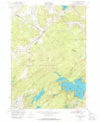
1951 Map of Lake Bonaparte
USGS Topo · Published 1988About this map
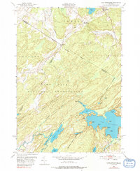
Lake Bonaparte dominates the southeastern portion of this 1950s survey, its intricate shoreline defined by Benton Point, Hitchcock Bay, and numerous islands such as Birch Island and Rock Island. The northern half of the region transitions into a landscape of small crossroads settlements and industrial pockets, including Balmat and Kellogg Corners, connected by the New York Central railroad line. A significant portion of the western territory is occupied by the Camp Drum Military Reservation, its boundary cutting diagonally across the terrain near Rices Corners. This military presence creates a distinct land-use pattern, cordoning off areas like Rockwell Creek from the surrounding civilian townships of Fowler, Diana, and Pitcairn. Further south, the Raquette River and Indian Lake highlight the water-rich geography of this Lewis and Jefferson County borderland.
Find a feature on this map
43 named features on this map. Tap any name to fly to it.
Don’t see what you’re looking for? This feature index may not catch every label — zoom into the map to look around manually.
Map Details
Editions of this 1951 Lake Bonaparte Map
5 editions found
Other maps of this area

1911 · Antwerp
USGS Topo · 1:62,500

1912 · Hammond
USGS Topo · 1:62,500

1913 · Lake Bonaparte
USGS Topo · 1:62,500

1915 · Gouverneur
USGS Topo · 1:62,500

1916 · Lake Bonaparte
USGS Topo · 1:62,500

1937 · Gouverneur
USGS Topo · 1:62,500

1944 · Hammond
USGS Topo · 1:62,500

1948 · Ogdensburg
USGS Topo · 1:250,000

1949 · Hammond
USGS Topo · 1:62,500

1949 · Antwerp
USGS Topo · 1:62,500