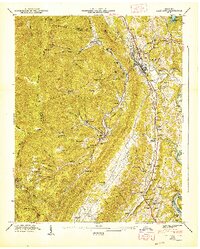
1947 Map of Lake City
USGS Topo · Published 1947About this map
Coal Creek winds through the heart of this Anderson County landscape, connecting industrial and residential hubs like Lake City and Briceville. The map reveals a post-war topography defined by deep valleys and the steep slopes of Vowell Mountain and Walden Ridge. The settlement patterns here are inextricably tied to the area's coal mining heritage, evidenced by the presence of the Miners Circle Cem and community clusters like Fraterville and Minersville.
Find a feature on this map
70 named features on this map. Tap any name to fly to it.
Don’t see what you’re looking for? This feature index may not catch every label — zoom into the map to look around manually.
Map Details
Editions of this 1947 Lake City Map
This is the sole edition of this map. No revisions or reprints were ever made.
Other maps of this area

1893 · Briceville
USGS Topo · 1:125,000

1895 · Briceville
USGS Topo · 1:125,000

1896 · Briceville
USGS Topo · 1:125,000

1936 · Block
USGS Topo · 1:24,000

1936 · Jacksboro
USGS Topo · 1:24,000

1936 · Duncan Flats
USGS Topo · 1:24,000

1936 · Windrock
USGS Topo · 1:24,000

1936 · La Follette
USGS Topo · 1:48,000

1936 · Norris Dam
USGS Topo · 1:48,000
1936 · Coal Creek
USGS Topo · 1:24,000