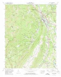
1973 Map of Lake City
USGS Topo · Published 1975About this map
Lake City and the surrounding mountain ridges of Anderson County are depicted here in the early 1970s, showcasing a landscape deeply shaped by the coal industry and early TVA developments. Extensive strip mines scar the heights of Cross Mountain and Vowell Mountain, while the valleys are dotted with historic mining communities like Briceville, Fraterville, and Minersville. The industrial legacy is further evidenced by a dismantled cable RR near Beech Grove and multiple rail lines following the contours of the land.
Find a feature on this map
80 named features on this map. Tap any name to fly to it.
Don’t see what you’re looking for? This feature index may not catch every label — zoom into the map to look around manually.
Map Details
Editions of this 1973 Lake City Map
This is the sole edition of this map. No revisions or reprints were ever made.
Other maps of this area

1893 · Briceville
USGS Topo · 1:125,000

1895 · Briceville
USGS Topo · 1:125,000

1896 · Briceville
USGS Topo · 1:125,000

1936 · Block
USGS Topo · 1:24,000

1936 · Jacksboro
USGS Topo · 1:24,000

1936 · Duncan Flats
USGS Topo · 1:24,000

1936 · Windrock
USGS Topo · 1:24,000

1936 · La Follette
USGS Topo · 1:48,000

1936 · Norris Dam
USGS Topo · 1:48,000
1936 · Coal Creek
USGS Topo · 1:24,000