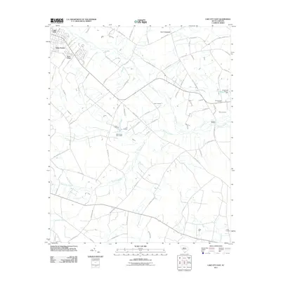
2011 Map of Lake City East
USGS Topo · Published 2011About this map
Lake City and its eastern environs are defined by a complex network of wetlands and agricultural tracts in the early 21st century. The landscape is dominated by the sprawling reaches of Lake Swamp, which meanders through the central terrain alongside smaller watercourses like Gum Branch and Singleton Swamp. Residential development is concentrated in the northwestern corner, notably in the Kelley Heights and Wren Village neighborhoods, while the remainder of the area maintains a rural character shaped by long-standing family landholdings and farm-to-market roads.
Find a feature on this map
82 named features on this map. Tap any name to fly to it.
Don’t see what you’re looking for? This feature index may not catch every label — zoom into the map to look around manually.
Map Details
Editions of this 2011 Lake City East Map
This is the sole edition of this map. No revisions or reprints were ever made.
Other maps of this area

1946 · Hyman
USGS Topo · 1:62,500

1946 · Kingstree
USGS Topo · 1:62,500

1946 · Lake City
USGS Topo · 1:62,500

1946 · Indiantown
USGS Topo · 1:62,500

1949 · Georgetown
USGS Topo · 1:250,000

1967 · Georgetown
USGS Topo · 1:250,000

1974 · Georgetown
USGS Topo · 1:250,000

1986 · Kingstree
USGS Topo · 1:100,000
1990 · Scranton
USGS Topo · 1:24,000
1990 · Pamplico South
USGS Topo · 1:24,000
Featured Places
- Lake City, SC
- Wren Village, SC
- Martha Law Estates, Lake City
- Kelley Heights, Lake City
- Lee Crossroads, SC