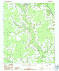
1990 Map of Pamplico South
USGS Topo · Published 1990About this map
Pamplico sits at the northern edge of this 1980s landscape, serving as a primary hub for a region defined by extensive wetlands and river systems. The Great Pee Dee River forms the northeastern boundary, featuring the prominent Dewitt Bluff, while the Lynches River cuts across the southwestern corner. Between these watercourses, the land is characterized by numerous bays and swamps, including Myers Bay, Cockfield Bay, and the sprawling Big Swamp.
Find a feature on this map
23 named features on this map. Tap any name to fly to it.
Don’t see what you’re looking for? This feature index may not catch every label — zoom into the map to look around manually.
Map Details
Editions of this 1990 Pamplico South Map
This is the sole edition of this map. No revisions or reprints were ever made.
Other maps of this area

1940 · Florence East
USGS Topo · 1:62,500

1945 · Florence East
USGS Topo · 1:62,500

1946 · Hyman
USGS Topo · 1:62,500

1946 · Johnsonville
USGS Topo · 1:62,500

1947 · Friendship
USGS Topo · 1:24,000

1949 · Georgetown
USGS Topo · 1:250,000

1953 · Florence
USGS Topo · 1:250,000

1954 · Florence
USGS Topo · 1:250,000

1967 · Georgetown
USGS Topo · 1:250,000

1974 · Georgetown
USGS Topo · 1:250,000