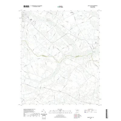
2020 Map of Lake City East
USGS Topo · Published 2020About this map
Lake City anchor the northwestern corner of this landscape, where the street grid of the town center transitions into the sprawling wetlands of the Lowcountry. The boundary between Florence County and Williamsburg County meanders through a dense network of water bodies, including the wide Lake Swamp and Singleton Swamp. This region is defined by its numerous family-named landmarks and rural burial grounds, such as Jones Cem, Lynch Cem, and Browns Chapel Cem. Transportation through these lowlands relies on established crossings like Browns Bridge, connecting scattered settlements like Lee Crossroads. The drainage pattern is complex, with McNamee Swamp and Parsley Swamp feeding into the larger system, illustrating the enduring relationship between the local geography and the rural communities that have settled along the high ground between these various branches and swamps.
Find a feature on this map
85 named features on this map. Tap any name to fly to it.
Don’t see what you’re looking for? This feature index may not catch every label — zoom into the map to look around manually.
Map Details
Editions of this 2020 Lake City East Map
This is the sole edition of this map. No revisions or reprints were ever made.
Other maps of this area

1946 · Hyman
USGS Topo · 1:62,500

1946 · Kingstree
USGS Topo · 1:62,500

1946 · Lake City
USGS Topo · 1:62,500

1946 · Indiantown
USGS Topo · 1:62,500

1949 · Georgetown
USGS Topo · 1:250,000

1967 · Georgetown
USGS Topo · 1:250,000

1974 · Georgetown
USGS Topo · 1:250,000

1986 · Kingstree
USGS Topo · 1:100,000
1990 · Scranton
USGS Topo · 1:24,000
1990 · Pamplico South
USGS Topo · 1:24,000
Featured Places
- Lake City, SC
- Wren Village, SC
- Martha Law Estates, Lake City
- Kelley Heights, Lake City
- Lee Crossroads, SC