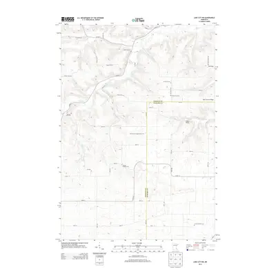
2013 Map of Lake City NW
USGS Topo · Published 2013About this map
West Florence Ridge and the deep drainage of Gilbert Valley define this landscape along the border of Goodhue and Wabasha counties. The area is characterized by a high concentration of small, denominational burial grounds that reflect the ancestral heritage of the local farming community. These include the Old German Evangelical Cem, the German Lutheran Cem, and the German Methodist Cem, often situated near rural intersections or along the high ground of the ridges.
Find a feature on this map
49 named features on this map. Tap any name to fly to it.
Don’t see what you’re looking for? This feature index may not catch every label — zoom into the map to look around manually.
Map Details
Editions of this 2013 Lake City NW Map
This is the sole edition of this map. No revisions or reprints were ever made.
Other maps of this area

1940 · Maiden Rock
USGS Topo · 1:62,500

1944 · Red Wing
USGS Topo · 1:62,500

1950 · Maiden Rock
USGS Topo · 1:62,500

1951 · Lake City
USGS Topo · 1:62,500

1952 · Red Wing
USGS Topo · 1:62,500

1953 · Saint Paul
USGS Topo · 1:250,000

1959 · Saint Paul
USGS Topo · 1:250,000

1968 · Goodhue East
USGS Topo · 1:24,000

1968 · Mazeppa
USGS Topo · 1:24,000
1974 · West Albany
USGS Topo · 1:24,000
Featured Places
- Belvidere Township, MN
- Hay Creek Township, MN
- Florence Township, MN
- Goodhue County, MN
- Wabasha County, MN