
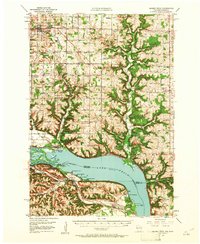
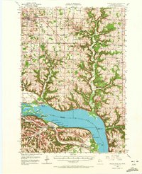
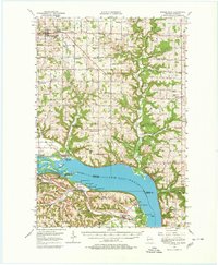
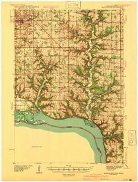
1950 Map of Maiden Rock
USGS Topo · Published 1952About this map
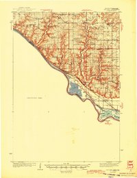
Lake Pepin dominates this mid-century topographic view, where the Mississippi River widens between the high bluffs of Pierce County, Wisconsin, and Goodhue County, Minnesota. The landscape is a dense network of upland farms and rural institutions, evidenced by the high concentration of named country schools like Sleepy Hollow School, Hill and Dale School, and Maple Grove School. The river economy is visible through the dual paths of the Chicago Burlington and Quincy and Chicago Milwaukee St Paul and Pacific railroads that flank the water. In Minnesota, the established community of Old Frontenac and the Villa Maria Academy sit near the riverbanks, while the Wisconsin side features the county seat at Ellsworth. This survey documents a critical period before post-war consolidation began to change the character of these riverside settlements and their many small school districts.
Find a feature on this map
87 named features on this map. Tap any name to fly to it.
Don’t see what you’re looking for? This feature index may not catch every label — zoom into the map to look around manually.
Map Details
Editions of this 1950 Maiden Rock Map
4 editions found
Other maps of this area

1932 · Wabasha
USGS Topo · 1:62,500

1935 · Arkansaw
USGS Topo · 1:48,000
1940 · Maiden Rock
USGS Topo · 1:62,500

1941 · Arkansaw
USGS Topo · 1:62,500

1942 · Arkansaw
USGS Topo · 1:62,500
1944 · Red Wing
USGS Topo · 1:62,500

1946 · Knapp
USGS Topo · 1:62,500

1946 · River Falls
USGS Topo · 1:62,500

1949 · River Falls
USGS Topo · 1:62,500

1949 · Knapp
USGS Topo · 1:62,500